Tag Archives: Dingbat (building)

‘Round Glendale: West Wilson Ave

Our inaugural look at development patterns in Glendale starts with W Wilson Ave, which runs from Brand Blvd, Glendale’s main street, to San Fernando Rd, which forms the border with Los Angeles and has a decidedly more industrial aesthetic.

For readers outside SoCal, Brand Blvd is Glendale’s main commercial street, home to everything from Glendale’s small skyscraper district to car dealerships to Rick Caruso’s wildly successful Americana at Brand, along with a wide variety of local businesses. Glendale’s early planners put a stunning view of the Verdugo Mountains to the north, and later planners in Los Angeles anchored the view to the south with the Library Tower. Brand serves as the west-east dividing line in the city, and it’s here we’ll start our journey down W Wilson Ave – down indeed, as this entire part of Glendale slopes gently west towards the LA River.

Downtown Glendale

Well, we’ll almost start at Brand. I’m going to cheat, and start one block east at Maryland, in order to offer up a couple more buildings. First up is the Maryland Hotel, one of only a few pre-war (World War 2, that is) multifamily buildings we’ll see. How do we know it’s pre-war? Fire escapes and no parking!

IMG_2923

Kitty corner to that is a construction site, future home of the Laemmle Lofts – a mixed-use development of 42 apartments, a restaurant, and a 5-screen movie theater.

IMG_2922

Across from that on the south side, there’s a one-story commercial building housing some restaurants and medical offices.

IMG_2924

This side of the block has a nice mid-block pedestrian court leading to The Exchange, one of the oldest developments of the “new” downtown.

IMG_2920

On the northeast corner of Brand and Wilson, there’s a Jewelry Mart in an older one-story commercial building, fitting since Glendale is the Jewel City.

IMG_2919

There’s another set of older one-story buildings across Brand, on the north side of Wilson, with small retail spaces that are the perfect fit for local and niche businesses. Los Angeles in general has a wealth of this type of space; let’s hope the commercial construction market picks up so that rents don’t start to rise too much.

IMG_2918

The building at far right is currently vacant; it used to be a Staples but apparently before that it was a Woolworth’s.

IMG_2927

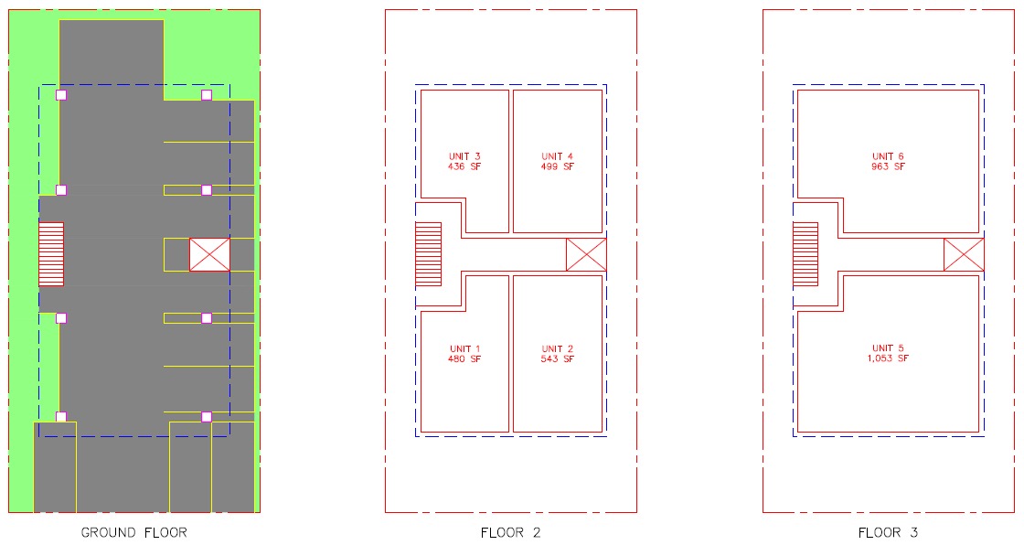
On the south side of Wilson, stretching from Brand to Orange, is a big, bold symbol of the new downtown Glendale: The Brand Apartments.

IMG_2925

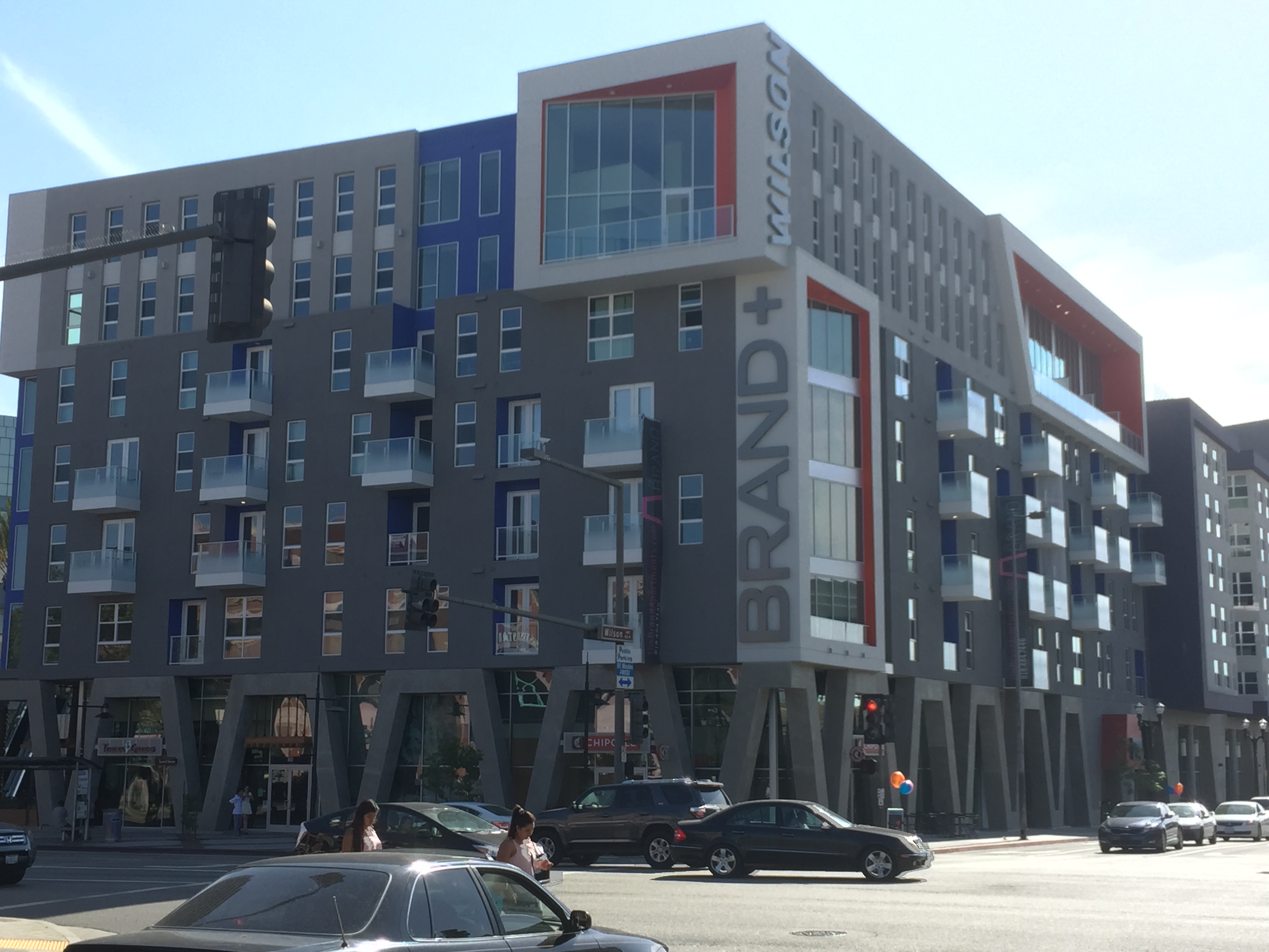
There’s a lot to talk about here, so let’s take a closer look. First off, let me say that I love this building. I think it looks great. Since it’s got frontage on Brand, which is by far Glendale’s highest-demand retail street, the retail filled up almost instantly with a Chipotle and a Tender Greens. They may not be your cup of tea but established brands that can pay higher rents are what you’re gonna get in new retail more often than not. The mix of businesses in the older building across the street is a reminder of the importance of having some old buildings. Of course, let’s not forget that if you don’t have any new buildings today, you won’t have any old buildings tomorrow.

Here’s a shot of The Brand showing its neighbor to the south, the 20-story Glendale City Center office building. I’m told the zoning at The Brand would have allowed for another 20-story building, but the market for high-rise residential just isn’t there.

IMG_2926

Here it is looking southeast back towards Brand.

IMG_2928

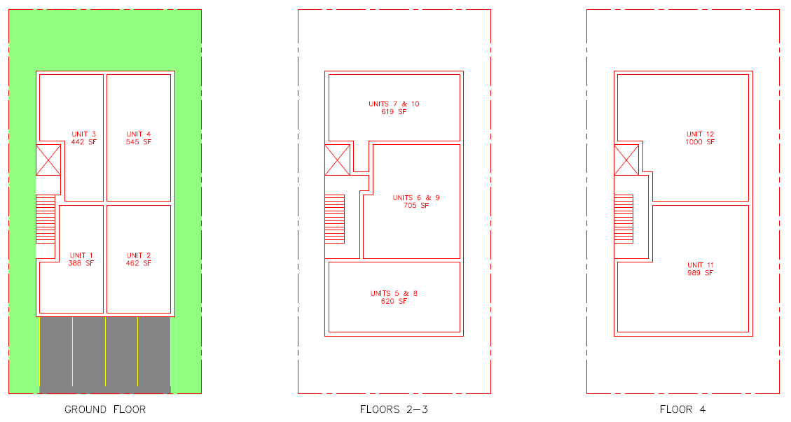
The next block west is the second part of the same development, and again, I think they did a fantastic job.

IMG_2929

The horizontal elements break up the façade nicely, the vertical stone-faced element is a beautiful accent, and the orange support is a nod to the first building that ties things together without being repetitive. The orange accents are also a nod to Orange St, which runs between the two buildings, and now has one of the more urban vistas in Glendale.

IMG_2930

Note how the second floor is cantilevered out over the sidewalk, with the balconies projecting further. Here’s another shot showing the second building doing that.

IMG_2913

A reliable source tells me that the edge of the second floor projection is at the property line. I like the effect; it creates a wider sidewalk at street level, but doesn’t make the street room feel any wider, so it still feels like a downtown.

The north side of the street here is another block of small, older one-story commercial buildings, home to a mix of small restaurants and retail.

IMG_2912

A Big 5, super convenient if you’re in need of outdoor supplies, takes us to Central on the south side, with the north side being a parking lot.

IMG_2911

The northwest corner of Wilson and Central is another strip mall, while the southwest corner is currently under construction with another mixed-use development.

IMG_2908

Development in this area is governed by the Glendale Downtown Specific Plan, designed to encourage mixed-use development – the “18-hour city” as official plans call it. The zoning for this area is shown below.

downtownSP

The zoning regulations of interest to readers are summarized below:

DSPchart

Note that the zones with the highest density, DSP/BC-B and DSP/BC-C, are occupied by The Brand apartments and Glendale City Center, but there’s a lot of area with 4-6 stories by right still available. Parking requirements are one spot for singles and 1-bedroom units, two spots for all others, and one guest spot for every 10 units for projects of 10 or more units. This probably sounds like a lot to many readers, though it’s less than required elsewhere.

Vineyard – Central to Columbus

Past here, we’re out of the Downtown Glendale Specific Plan and into West Glendale, or Vineyard if you want to get particular about it, and development changes to smaller scale, all residential buildings. If you haven’t already, you’ll want to open up Google Earth and turn on 3D buildings so you can see what’s really going on; it’s totally impossible to figure it out from the street! Development here offers a lot of inspiration for how to densify existing single-family neighborhoods, but wily West Wilson hides a lot of its tricks from view.

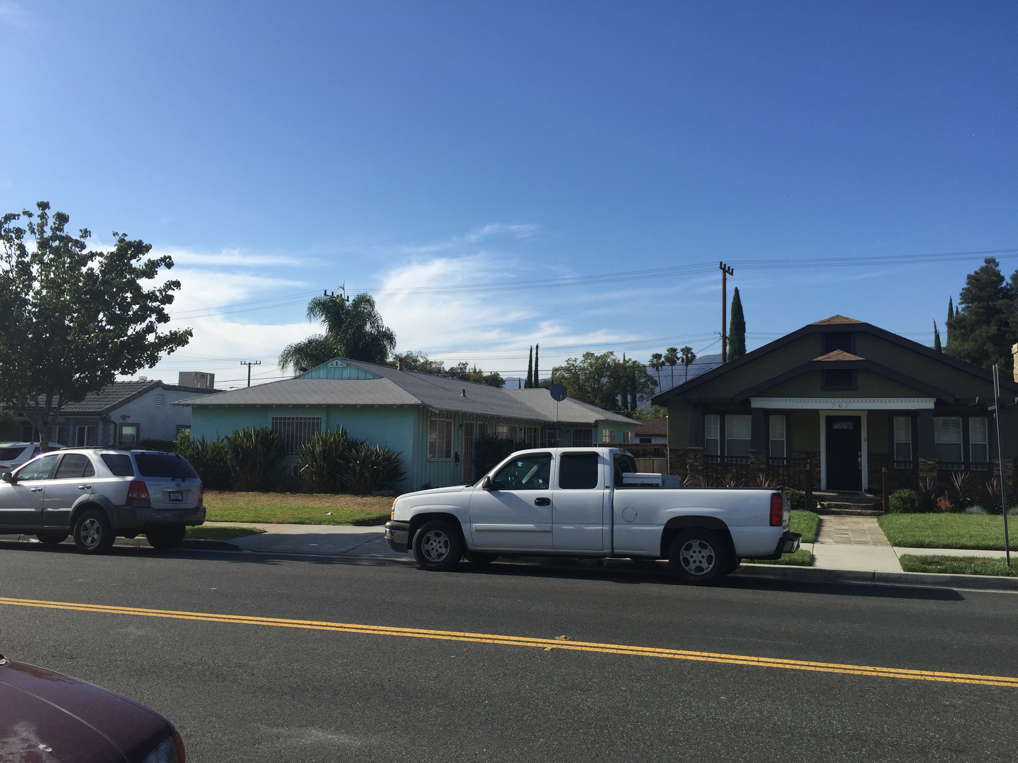
First up, this handsome pre-war apartment block called Canterbury Court. Note its size relative to its neighbor! The Tudor-ish façade is interesting too, since that style enjoyed a renaissance during the 1980s apartment boom, as we’ll see later. The age of many buildings on Wilson is missing in this handy database, but it does have data for Canterbury Court – 1928.

IMG_2906

The first building on the south side of the street is this single-family house, with an accessory dwelling unit (ADU) behind it not shown.

IMG_2905

West of that is our first trick building. From the street, it looks like a simple fourplex, with numbering (330, 330 ½, 332, 332 ½) that evokes prewar patterns.

IMG_2903

Check it out in Google Earth, though, and this fourplex has a hidden ADU building (can we call it a rear house!?) that looks like it has another four units! This unimposing lot appears to be developed at close to dingbat density.

On the north side, we have three larger 1980s apartment blocks (the underground parking is a dead giveaway as to the era of construction).

IMG_2907 IMG_2904 IMG_2902

This one is harder to place (it’s 1975), but I really like the twin chimneys and peaked roof.

IMG_2934

Back to the south side, we’ve got a classic dingbat (1961) and a building that I’m guessing is from the 1980s just because it looks like boatloads of unprofitable condos built around Lake Tahoe at the same time (and indeed, it’s 1987).

IMG_2932

The next building west puts on the front of a single-family residence (SFR), but it’s got an ADU out back and it’s actually a duplex itself.

IMG_2935

Moving back to the north side, we’ve got an SFR and a dingbat, built in 1962.

IMG_2937

Well, at least that’s what we have in front! The dingbat’s got a rear house that appears to be two more units, and the SFR has an ADU building.

IMG_2940

West of that, there are three buildings that genuinely appear to be SFRs.

IMG_2942

Back to the south side again, there’s another classic dingbat, and an older SFR.

IMG_2939

We’ve then got another dingbat with a rear house (built 1963) just peeking out into view.

IMG_2941

A newer single-lot apartment building (built 2005) and two large dingbat-like buildings (1986 and missing) take us to the corner of Columbus on the south side.

IMG_2944

On the north side, three SFRs take us to Columbus. The first has a couple units over a carport in the back, and the second has a single ADU. The houses all date to the 1910s and 1920s.

IMG_2946 IMG_2947

Vineyard – Columbus to Pacific

This block starts with a bang, with dueling dingbats on the corners, both built in 1963.

IMG_2949 IMG_2950

After that, on the north, we have an SFR with a four-unit rear house behind it, and a large 1984 building.

IMG_2952

On the south side, we have a single SFR (just visible on the left), and an SFR with a multi-unit ADU behind it.

IMG_2954

This is one of the trickiest blocks on W Wilson; housing units are everywhere – blink and you’ll miss them. Fortunately we have an alley between Wilson and Broadway to help us get a little better view on the south side. The next two buildings on the south side are what looks like an SFR and, um, what?

IMG_2955

Maybe we can get a better view from the back.

IMG_3047

Yep, that’s three cottages with a two-unit rear house over a carport. And surprise: totally invisible from Wilson, there are two little buildings behind the SFR

Next up is another larger structure, dating to 1991, the very tail end of the 1980s boom.

IMG_2956

This is followed by another SFR with a four-unit rear house.

IMG_2957 IMG_3048

Note that there is a wide variety of shapes and sizes, but the size isn’t necessarily a good proxy for number of units! In fact, the adjacent building to the west is a newer project, taking up 4 lots, but appearing to only have 18 units (4.5 units per lot, the maximum allowed by the current zoning). They’re certainly larger units, but on a dwelling unit basis, this building is less dense.

IMG_2959

Back on the north side, we have two SFRs, but they both have ADUs, hidden but for the subtle house number that can be seen at the edge of the yellow house.

IMG_2960

There are also two SFRs across the street on the south side, and the one on the right looks to be the only unit on the lot. The one on the left has a second house in the back, hidden from view on Wilson.

IMG_2961 IMG_3050

There are two more SFRs to the west on the south side, with the left one harboring a four-unit rear house, and the right one harboring a small parking lot for, um, what? The buildings across the alley?

IMG_2963 IMG_2962

The north side of the street is much more straight-forward: several 1980s apartment buildings and then two SFRs to take us to the corner of Pacific. The apartment building on the right is from 2002.

 IMG_2964IMG_2967

The south side finishes up with two SFRs that, of course, have ADUs out of sight. They’re actually big enough to be called houses in their own right.

IMG_2968

Vineyard – Pacific to Concord

Ok, ready to push through the last block? Well, plus a little coda, and a zoning discussion?

As we’ll see, the further we get from downtown Glendale, the less dense the development gets. The southwest corner of Pacific and Wilson is the last big pre-war multi-family building we’ll see. The architecture, lack of parking, and numbering scheme (500, 500 ½, 502, 502 ½) are the giveaway.

IMG_2969

Next, there’s a few SFRs; the one on the left has an ADU in the back. With only a few exceptions, the SFRs on this block date to the early 1920s.

IMG_2970IMG_2972

The north side of the block starts out with SFRs as well; I think the center one in the first picture has an ADU but it’s hard to tell from the street. The house in the center of the second picture definitely does, but it’s not easy to see. The one on the right in the last picture also has an ADU, which can be seen in Google Earth.

IMG_2971 IMG_2974 IMG_2976

On the south side, we have the first large apartment building on the block, taking up two lots. This building was built in 1979, before any downzoning, at the head end of the 1980s boom.

IMG_2977

Two true SFRs with no ADUs on the south side take us to Kenilworth Ave, a small local street.

IMG_2978

Next, on the north side, we have a single SFR, followed by a large 1985 apartment building that takes up four lots and appears to have about 20 units. The landscaping on the street makes it almost impossible to see all four buildings at once.

IMG_2981

On the south side, there’s a 1987 building and a 1963 building, both typical for their time.

IMG_2985

This is followed by a small SFR set so far back on the lot that one might conclude this was originally an ADU to a dearly departed main dwelling. However, if that’s the case, the original house has been gone since at least 1989, Google’s oldest aerial image for the region. The sign out front announces a proposed triplex on the site, the greatest number of units allowed by the current zoning.

IMG_2984

Next to that is a 1980s-looking building that shows how much more density was previously allowed.

IMG_2986

Back on the north side, there’s an SFR with an ADU peeking out; in Google Earth, it looks like the rear building actually has two units.

IMG_2987

The next house west straight up has a second house in the back yard.

IMG_2988

On the south side, there are two handsome SFRs; at left, an ADU can be seen, and there is a third unit totally hidden from view.

IMG_2989

Next to that is a large apartment block on two lots – two buildings, not identical but fraternal twins, dating to 1983 and 1985.

IMG_2993

Further down, a classic modern stucco apartment house from 1963 (hey, didn’t we see you on dingbats dingbats dingbats?) and a Tudor-ish 1974 building on four lots.

IMG_2994

Across from that, on the north side, are several SFRs; all but one have ADUs, but you’ll have to look in Google Earth to see them.

IMG_2991 IMG_2992

The north side of the block continues to stretch west with SFRs; some have ADUs, while others are actually duplexes, a type we haven’t yet seen much of on Wilson.

IMG_2996 IMG_2999 IMG_3003 IMG_3004 IMG_3009 IMG_3010

You’ll really have to look closely in Google Earth and Street View to try to see what’s what. Here’s a few where you can catch a glimpse of the ADU.

IMG_2995 IMG_3006 IMG_3020

Here’s one of the more obvious duplexes.

IMG_3021

Rounding out the residential units on the south side, we have an SFR (with an ADU not shown) and a dingbat with a rear house.

IMG_2997 IMG_2998

There’s a large one-lot 1973 building and then two true SFRs without ADUs.

IMG_3002IMG_3001

The south side then goes industrial, with some single story office/warehouse type buildings.

IMG_3005 IMG_3007

Vineyard – Concord to San Fernando

The last little block takes us down to San Fernando Rd, which runs next to the Metrolink tracks that form the boundary with Los Angeles. This block is made up of one-story industrial uses.

IMG_3012 IMG_3013 IMG_3017

At the corner of San Fernando, there’s a small local hangout.

IMG_3015

Vineyard – Zoning

Zoning west of Central is covered by Glendale’s general zoning plan.

generalzoning

From east to west, the blocks of W Wilson are zoned R-1250, R-1650, R-2250, and IMU. The R zones are residential multi-family zones, where the number indicates the required lot area in square feet per unit. IMU is industrial/commercial mixed use. Parking requirements are 2 spots per unit, except 2.5 spots for 3-bedroom units and 3 spots for 4-bedroom units.

Thus, the permitted residential density on W Wilson steps down as you head west towards San Fernando Rd. Lots on the north side of Wilson appear to be about 50’ x 140’ lot, which translates to 5, 4, and 3 units per lot; on the south side, lots appear to be about 50’ x 175’, which translates to 7, 5, and 3 units per lot.

Which Way, W Wilson?

West Wilson Ave presents an interesting variety of residential housing types, from single-family houses to large apartment buildings, backyard cottages to dingbats with rear houses. In these few blocks, it captures both the opportunities and challenges for housing in greater LA in general.

The housing types of W Wilson point the way forward for natural growth of less dense neighborhoods, such as centrally located single-family areas. These options – ADUs, rear houses, small apartment buildings – are some of the best ways to improve housing affordability. They’re lower cost to construct, and don’t result in the loss of a lot of existing units. They allow for an evolution of building types rather than a sudden change. There are still development opportunities on Wilson; you could buy one of the remaining SFRs and built townhouses or put up some ADUs in the back. We would do well to allow other neighborhoods to grow the way Wilson did.

On the other hand, this area was clearly downzoned in the 1980s. There are lots occupied by SFRs where you can only build 3 or 4 units, despite the adjacent lots having 7 to 10 units. If housing prices in LA continue to rise, there will be pressure to redevelop lots that are currently occupied by a SFR and a few ADUs. Under the current zoning, we won’t end up with more housing units, just larger, newer, more expensive units. In some cases, redevelopment might result in a net reduction of units. It shouldn’t be a radical idea that new development be permitted to be at least as dense as its neighbors. Would a few 5-story buildings really make a big difference in how the street feels?

The foot of Wilson Ave, along with San Fernando Rd itself, is worth looking at in more detail, in a future post. For now, development patterns on Wilson Ave stand as proof that we do know how to do mixed-use projects and residential density in the LA region, when we let ourselves do them.

‘Round Glendale: Dingbat Quartet

Now that blog headquarters is in Glendale, it’s time to reboot the ‘Round Palms department to take a closer look at housing and development patterns in the Jewel City. There will be some more detailed posts coming up, but for now, an appetizer: this four-pack of dingbats located on Chester St just south of the 134 freeway.

Chester-overview

These four buildings are all built from the same plan, with two being mirror images of the other two. This lends some variability to the view from the street but also creates a pleasing symmetry. The southernmost building fronts on Doran St as well as Chester St.

IMG_2840

The matching staircases, one rotated at 90 degrees to the other, is a nice touch. Here’s the skinny end of the next building north, fronting on Chester St only.

IMG_2841

The next building north is a carbon copy of the southernmost building. Note that while these buildings started the same, over time they’ve acquired some individuality. While the first building has original construction and the second hasn’t even managed to lose its window bars, this one has managed to acquire some new windows.

IMG_2842

As any dingbat resident can tell you, that’s a major improvement: the original construction featured drafty, rattling, leaky single-pane windows that do almost nothing to stop the transmission of sound. The denizens of this building are enjoying better climate control and more respite from the sounds of the street and the nearby freeway.

By using mirror images of the plan, the designers created a little open space between the second and third buildings, pleasant enough to support a few large trees and children’s swing.

IMG_2843

It’s perhaps a little surprising that the architect didn’t flip all four buildings, creating two courtyards, but apparently they wanted to have the open side of the southernmost and northernmost buildings fronting the street.

The northernmost building, fronting on Pioneer Dr, appears to have received the most love through the years, receiving not only new windows, but fresher paint and, if you look closely, some reinforcement for the railings on its exterior walkways

IMG_2844

In addition to providing some courtyard space, a nice feature of these buildings is that, unlike most dingbats, the parking is not featured front and center, but rather tucked around the back off of a small alley.

IMG_2845

This appears to have been accomplished by assembling several lots and adding an alley where none existed before. If you go back and look at the first image, you’ll note that these buildings are oriented perpendicular to all the other lots on Doran and Pioneer. These lots are about 50’ wide and 115’ deep, and the dingbat quartet was constructed on six lots put together. Putting the parking in back, off-street, is a nice design feature that improves the final result. As we’ll see in future posts, this seems to be more common in Glendale apartment buildings from the 1960s boom than in places like Palms.

Dingbat City

Long time readers know that this blog holds the dingbat in high regard, perhaps not for its architectural styling, but as a symbol of a development process that allowed natural evolution of neighborhoods and created tons of instantly affordable housing at a time of rapid growth in LA. Indeed, we’ve gone so far as to suggest that if we want to increase affordability in LA, we need to figure out how to resurrect the spirit of the dingbat.

Dingbats, like any mass-produced building type, have their shortcomings. These are mostly related to use of cheap construction materials for things like windows, poor insulation and soundproofing, and seismic issues stemming from their iconic open carports (which were poorly understood at the time). However, a recent opinion column in the Santa Monica Daily Press tries to conflate these fixable problems with fatal, but fictional, flaws related to density and design, and then conflate dingbats with the five-story podium buildings that, thanks to a recent downzoning, won’t be built on Santa Monica’s commercial boulevards.

After lampooning an architect who improved many people’s lives by making possible for them to move to Los Angeles instead of trying to keep them out, the column reaches the crux of its anti-dingbat argument by asking:

“Don’t most people want. . . elements missing from the dingbats. . . light, openness, blue sky, scale and proportion, privacy, sustainability, and amenities such as courtyards, with trees and landscaping, that enhance one’s quality of life?”

You know what else enhances one’s quality of life? Not having to spend an exorbitant portion of one’s income on housing! Maybe you want trees and landscaping, or the light that so many buildings are said to lack, though I’ve never heard of a dingbat denizen dying from lack of sunlight. On the other hand, maybe you’re working two jobs, or both working and attending school. You need a low-cost apartment, and the “scale and proportion” is the last thing on your mind. Why should a bunch of NIMBYs decide what type of housing you can have? Shouldn’t you get to choose?

In an effort to get you to think that no, you shouldn’t, the column pivots to a discussion of the need to trim one’s wish list when building a dream home, likening it to trimming the development density allowed in Santa Monica’s Land Use and Circulation Element (LUCE). But of course, a downzoning isn’t about NIMBYs trimming their wish lists, it’s about everyone else – young people, low income residents, recent arrivals – making sacrifices for the NIMBYs.

In trying to make that leap from two-story dingbats to five-story podiums, the column falls flat. Modern podium buildings are much better buildings than dingbats thanks to advancements in construction technology, improvements in building codes and design, and the state energy code. Many of the new podium buildings recently constructed in Santa Monica – the kind the column’s author doesn’t want any more of – include the amenities whose absence in dingbats the column bemoans. In fact, the downzonings favored by NIMBYs will help to ensure that many people have no affordable housing option other than the dingbats. It’s kind of strange to slag the dingbats, and then oppose the construction of modern housing too. If you want people to have options other than dingbats, you might want to advocate for those options to be built.

The truth is that NIMBYs don’t really care about building design that much; they just don’t like any density. Likewise, they will pretend to care about affordable housing to the extent needed to align politically with people who oppose development for other reasons, like displacement. For example, a previous column in the Santa Monica Daily Press called for increasing housing affordability by converting office space to residential, a plan that could only have an impact on housing prices if it drove up commercial rents and started forcing small businesses out of Santa Monica. NIMBYs don’t have to care about design or affordability, but they should be called on it when they pretend they do.

As for the stucco box vernacular, you don’t have to love it, but until you have a plan to mass produce higher-quality affordable housing, you should at least respect it.

Courtyard Buildings

Rumor has it that there’s interest in LA’s courtyard apartment buildings, and in why you don’t see many of them built anymore. As you might guess, my suspicion is that zoning and parking requirements, along with availability of land with the needed zoning, are the primary causes. So, let’s take a closer look at this common Los Angeles building typology.

Low-rise courtyard apartment buildings are as much a part of the Angeleno vernacular as the dingbat, found all across LA’s multi-family neighborhoods. Typically, they consist of a roughly donut-shaped building, with a rectangular courtyard having its long side perpendicular to the street forming the donut hole. Entrance to the courtyard is through an open or gated breezeway through the first floor. The apartments ring the courtyard, usually only a couple stories high, but occasionally more. Parking is tucked underneath the sides and rear along the outside of the building.

Palms (where else) is a great neighborhood for looking at examples of courtyard apartments. I once wrote a post where I pretty much called Clarington Avenue dingbat heaven; head just one block west to Jasmine Avenue and you’re in courtyard central.

Jasmine

As is so often the case, this now-beloved building type was an unintended consequence of planning and zoning regulations, and courtyard apartments were maligned in the era of their construction. In 1974, during contentious public hearings for the Palms-Mar Vista-Del Rey Neighborhood Plan, LA City Planning Commissioner David Roper stated that the city’s open space ordinance “had failed because developers put the space in the middle of the apartment buildings, the so-called hole in the donut, out of view of the public.” (Likewise, in the early 1970s, City Councilor Louis Nowell was being maligned for approving the construction of corner gas stations – which, by the early 1980s, were being replaced by mini-malls at such a furious pace that the fusspots were worried about them. Notice a pattern?)

As you can see in the aerial, a courtyard apartment building is really just two dingbats that teamed up to increase the overall value of the project. Single-lot dingbat projects penciled out, and many were built, but given setback and parking requirements, the parking and apartments were about all you could fit on the lot. You’ll rarely, if ever, find a single-lot dingbat with a courtyard or pool. By putting two lots together, you eliminate 10’ of side setback requirements for an R3 or R4 zone, and make it easier to configure the parking. The skinnier courtyards aren’t much more than 10’ wide, though current zoning requires them to be 15’ to count towards open space requirements.

Revisiting some proposed prototype projects from the dingbat post, here’s what we had for R3 density (top) and R4 density (bottom) projects. The R3 project meets current parking and setback requirements; you could meet open space requirements if you reconfigured the parking. The R4 project meets setback requirements but not parking requirements. It would meet R3 open space requirements, but not R4.

WV2

SLA2

As an aside, I’m not sure why the zoning code should specify open space requirements beyond what it already has for setbacks. The code claims it’s for children’s play space and outdoor recreation, though no one seems to know if it’s used as such. Like parking requirements (1 spot for a studio, 1.5 spots for a 1BR, and 2 spots for anything bigger), open space requirements increase steeply with apartment size (100 SF for a studio, 125 SF for a 1BR, and 175 SF for anything bigger), thereby greatly punishing development of larger apartments and helping to ensure there won’t be any children in the development.

However, it’s certainly easier to meet parking and open space requirements when you put two lots together. Here’s a look at two similar prototypes, using the same development concept but with two 50’ by 100’ lots instead of one.

WV3 SLA3

In the concepts above, the top option, providing 12 1BR apartments, meets parking and open space requirements. And indeed, this is pretty much what you see in later stage developments all over Palms. The parking is usually depressed below street level as much as reasonable to improve aesthetics, putting what I’ve called “Floor 2” closer to being the ground floor, with parking in the basement.

The bottom option, providing 8 studio/1BR, 12 2BR, and 4 3BR apartments, does not meet current parking or open space requirements. By avoiding a basement parking level, the need for a concrete podium is avoided, significantly driving down costs. Putting parking right out front isn’t very aesthetically pleasing, but it would provide some spots that could be rented separately from the apartments, keeping rents lower. In many neighborhoods in LA, there are lots of people who don’t own cars, and making them pay for a parking spot or podium construction would put this new construction out of their reach. If an alley is available, parking could be flipped to the back, and the yard to the front, for a considerable improvement. Open space requirements could theoretically be met by adding a roof deck, though this would increase costs.

Clearly, combining two lots creates the opportunity to provide more amenities. The courtyard creates a semi-private space and the sides of the apartments facing the courtyard feel more protected from the rest of the city. Nevertheless, as stated in the dingbat post, I think it’s important to make sure that single-lot projects pencil out. If two or more lots are needed, one owner can have undue leverage to block housing development. If single-lot developments work, owners are given a positive incentive to work together to create higher value projects.

As for getting more of these projects built, there’s really no secret: we need less land zoned R1 and RD, and more land zoned R3 and R4. If we want more affordable projects, like the second option, we’ll need to ease up on parking and maybe open space requirements. It’s really that simple.

Dingbat Renaissance

Note: for ease of understanding, all costs, prices, rents, and so on are presented in 2014 dollars, adjusted from 1964 dollars per the BLS inflation calculator.

Discussions on affordable housing in Los Angeles, and California in general, often include debate on how to maintain existing affordable housing stock. These buildings, constructed mainly in the 1950s and 1960s, are referred to as dingbats. They are invariably low-rise wood-frame and stucco construction, though there’s some variability in scale, from the classic single-lot six-unit dingbat to larger buildings constructed on several assembled single-family lots.

While there’s a lot of interest in preserving the affordable housing units in these buildings, there’s a curious lack of interest in how dingbats came to exist. Despite the fact that many were speculative, they were purpose-built affordable housing, and they were built in mass for decades. It stands to reason that a city facing a huge shortage of affordable housing should want to understand how the dingbats were built, and if we might build large amounts of affordable housing by the same process today.

Fortunately, the dingbats are not a mystery. In The Low-Rise Speculative Apartment, published in 1964, Wallace Francis Smith offers a detailed analysis of the dingbat construction boom then taking place in Oakland. Presciently, Smith concluded that dingbats were serving a useful function in society, and that their construction ought to be encouraged. As we will see, the opposite happened, but to start, let’s consider the factors that, per Smith, enabled construction of dingbats:

  • Savings looking for investment, and thus lending institutions with excess lending capacity.
  • Investors looking to buy small residential properties upon completion.
  • Depreciation tax incentives that made the properties attractive investments for high-income individuals, even if the nominal net cash flow from operations was very small.
  • Low cost of land per dwelling unit (du), median $10,700.
  • Low cost of construction per du, median $47,185.
  • Short duration of construction, median 7-9 months but as little as 3 months.
  • Zoning that allowed single-family residences (SFRs) to be replaced by dingbat apartment construction.

Parking requirements, as enacted by Oakland in 1961, were determined to increase construction costs, but not to the extent that they stopped construction altogether. Rather, marginal projects (which logically include the most affordable dwelling units) became impossible to build profitably.

These conditions produced a large quantity of affordable units. One bedroom units, averaging 635 SF, rented for an average of $820/month. Two bedroom units, averaging 835 SF, rented for an average $1,055/month. You can scarcely rent something in the oldest buildings in the cheapest neighborhoods in LA today, let alone new construction.

Dingbat Factors Today

Ok, all of that is great for people in 1964. What about 2014? Could the same combination of factors allow for a boom in affordable housing construction in Los Angeles today?

The first three factors relate to availability of financing and willing investors. This is not the area of expertise for this blog, but lending capacity does not seem to be an issue. Neither does the ability to find investors; consider the current level of foreign interest in owning real estate in US cities. Tax structures relating to depreciation are not something that can be addressed at the city level, and would require federal action.

The next three factors concern the costs of planning, permitting, and building the project. Cost of land per dwelling unit was very low for the dingbats. Assuming R4 zoning, which allows 12 du on a 5,000 SF lot, you’d have to be able to buy such a lot for $125,000 to get similar land costs per unit. You simply cannot find buildable lots that cheaply in LA today.

Construction costs were also very low, with the figures above equating to about $75/SF for building a dingbat. This is not out of line for construction of SFRs today; you can buy new SFR construction for as little as $85/SF in places like Adelanto. Perhaps it’s possible to see classic dingbats as big SFRs. On the other hand, dingbat construction is universally considered to be low quality, good enough only to meet the building codes of the time, lacking in amenities like, say, soundproofing between apartments. In addition, changes in seismic building codes in response to the 1970 Sylmar earthquake and the 1994 Northridge earthquake have undoubtedly increased construction costs for structures with open stories on the ground floor, like the classic dingbat carport. Today’s multifamily construction costs are much higher, often over $200/SF.

Duration of construction indirectly impacts construction costs, because carrying costs are increased when the duration of construction is longer. Much construction, including many of the original dingbats, is financed by a construction loan, which is paid off and replaced by a permanent loan when the building is complete (or when the speculative builder sells the completed building to an investor). Construction loans usually have higher interest rates than permanent loans. The faster construction can be completed, the faster the building can be put into revenue use and the construction loan retired. The city can reduce duration of construction by facilitating permitting and working to schedule building inspections so that they minimize downtime on the jobsite.

Lastly, there’s the need for zoning that allows dingbat construction. In LA, this generally means R3 or R4, which allow 6 du and 12 du on a typical 5,000 SF (50’ by 100’) lot, with R3 corresponding to the classic image of a dingbat. R5 zoning allows 25 du on such a lot, but this can’t practically be accomplished with wood-frame construction given setback, height, and floor-to-area (FAR) zoning requirements. Since 1970, zoning changes have significantly reduced the amount of R3 and R4 zoned land, especially in areas like the Westside. While small apartment buildings are still built in neighborhoods like Palms, in most places, they are precluded by zoning.

Parking requirements are part of zoning; in LA, zoning stipulates 1 spot per studio, 1.5 spots per 1 bedroom apartment, and 2 spots per 2+ bedroom apartment. As we shall see shortly, they have a major impact on the cost and feasibility of small apartment building construction, particularly on small lots.

Let a Thousand Dingbats Bloom

Given these parameters, let’s try to make dingbat construction work today, and see what cost inputs we might be able to change.

Dingbat, 1964

Now, what do good engineers do before performing tests? They calibrate their equipment! So first, here’s a shot at analysis of dingbat construction in 1964.

dingbat costs

The columns on the left present a breakdown of total costs and costs per unit. “Soft costs” refers to things like design and permitting; other cost categories are hopefully self-explanatory. At center, you can see we are assuming a classic 6-unit dingbat, the typical 635 SF 1-BR apartment size, and construction costs of $75/SF. “Efficiency” refers to the ratio of usable apartment space to total building size, which includes unproductive areas like stairwells. At right are assumptions for several cost categories: soft costs are assumed to be 10% of construction, marketing 1% of construction, carrying costs 8% of land plus demolition plus construction, and profit 6% of land plus demolition plus construction.

To convert this to a monthly rent, we first calculate a monthly mortgage payment by taking the cost per unit and amortizing it out over 30 years, at an assumed loan rate of 6%. Since rents must also cover building operating costs and unit vacancies between tenants, we divide the mortgage payment by 70% and then 95%, thereby accounting for 5% vacancy and operating costs equal to 30% of gross rents. Operating costs of 30% are a little on the lean side for LA apartment buildings, but not unreasonable.

And, voila! We get a monthly rent in the vicinity of the rents reported by Smith in 1964. Note two things here. First, a rough guess of monthly rent is about 0.90% of total costs. This is a little higher than some other estimates I found (0.75% to 0.80%), but let’s err on the side of caution. (If you assume an equity investment of 20%, you could cover the mortgage and operating costs with monthly rent of 0.73%.) Second, we can assess the contribution of each cost category to monthly rent. As you’d expect, construction costs dominate, followed by land costs.

Palms West, 2014

Back to the present. What would a small development look like on the Westside? Fire up ZIMAS and look to the north and west of Palms, and you’ll see large areas in yellow, which indicates R1 single-family zoning.

ZIMAS

Looking at some of the less expensive areas, you can find an SFR in for something like $800,000. Let’s assume it’s upzoned to R3, which would allow six units. I know a lot of readers don’t like bundled parking, but for the sake of argument, assume it’s hard to sell condos in these neighborhoods without parking. Since they’re primarily single-family, there’s not a lot in walking distance and it might be a hike to decent transit. Yes, condos. Not your parents’ dingbats, but when you’re paying that much for land, it’s probably the way to go. Here’s one possible configuration, meeting city parking and setback requirements.

WV1

Four stories, parking on the ground level, and two units per floor above that. I assumed elevators would be required for all buildings. This gives you as simple a design as possible for the podium, which would probably have to be concrete. Costs are presented below.

Westside 1 costs

Soft costs were increased to 15%, to account for increased permitting and design costs, and marketing to 8%. Construction costs were assumed to be $225/SF, a rough estimate based on a variety of sources for podium type construction. Could you sell these generously sized 1-BR condos for about $525,000 on the Westside today? I think so.

Here’s another option for Westside development, with a three-story building that has four small units and two large units. I bumped construction costs up to $250/SF to account for the higher proportion of concrete.

WV2

Westside 2 costs

For this option, I split all costs except construction equally among the units. This gives some units just under $400,000. Distributing costs differently would decrease the price for the small units, but increase it for the large ones.

Vermont Knolls, 2014

Fine, you say, but wasn’t the point of this post to look at affordable housing? Let’s take this model to Vermont Knolls, a part of South LA bounded by the 110, Normandie, Manchester, and Florence. Some areas are zoned R3, but most are zoned for less density (RD, R2, or R1). Here, the cost of a single-family lot is something like $300,000.

To drive down the cost of land per unit, let’s assume it’s upzoned to R4, which again allows 12 du on a normal lot. Here, we can really see the impact of parking requirements. Even if all 12 units are nominally studios, the zoning requires 12 parking spaces, which would be nearly impossible to configure on a 5,000 SF lot with only 50’ of street frontage. Let’s assume the city eliminates parking requirements; we’ll still throw in a few parking spaces out front – they’re nearly free and would generate some additional revenue.

SLA1

Three stories, four apartments each floor. Construction costs were assumed to be $140/SF, on the low end of what I’ve seen for low-rise construction in LA. Soft costs were dropped back to 10%, on the assumptions that design costs would be reduced by working from a cookie cutter plan and that the city would facilitate permitting and inspection. Marketing was dropped to 1%; affordable apartments rent themselves.

South LA 1 costs

Hitting rents under $1,300/month is a big deal. Why? Well, if we raise the minimum wage to $13/hr, a full-time minimum wage worker would make about $26,000/year. A two-worker household would earn about $52,000/year. Using the 30% of income standard, a brand new $1,300/month apartment is affordable for such a household. If construction costs could be driven down more, all the better; for example, at $100/SF, the rent would be about $1,000/month.

Here’s another option, going with four stories and a mix of studio/1BR (ground floor), 2BR (floors 2-3), and small 3BR apartments (floor 4). Costs were apportioned the same way as the Westside plan.

SLA2 South LA 2 costs

I’m not sure if these larger size apartments would be competitive with existing rental stock. Again, driving construction costs down would make a big difference; at $100/SF, the 1BRs would be about $1,000/month, the 2BRs around $1,200/month, and the 3BRs $1,550/month.

ADU Sidebar

What’s even more affordable than dingbats? Accessory dwelling units. These can be very basic one-story wood-frame projects. If the property owner does the development, there’s no land or demolition cost, and we can safely assume true SFR construction costs, say $80/SF. For a 700 SF ADU, we get the following costs.

ADU costs

Importance of Single Lot Projects

Readers have probably noticed that all the development concepts in this post are based on single lot projects. Lot assembly greatly facilitates things; for example, by putting two lots together, you eliminate the lost space of the side setbacks between them, which lets you offer larger apartments. This will also drive down costs per square foot, because larger apartments usually include more cheaply built living space, rather than more expensive kitchen and bathroom space.

However, I think the ability to profitably develop a single lot is crucial, because it eliminates the potential for adjacent owners to hold out for huge payouts. Indeed, as Smith notes, most of the original dingbats were built without even considering lot assembly, which was deemed to add too much time to the process. If a single lot can be developed profitably, it’s mutually beneficial if adjoining owners decide to consolidate and develop a larger building. This also eliminates the need for city planning agencies to go down into the weeds and use eminent domain to assemble lots large enough to be feasible. The city could facilitate single lot projects by reducing or eliminating parking requirements and reducing setbacks.

Be Proactive, Not Reactive

An approach to affordable housing that strives to enable market-rate construction of projects like these all over the city is a more proactive policy. Trying to save existing affordable units, while necessary in the short run due to California’s terrible housing situation, can only slow down, but never reverse, the worsening affordability problem. Note that projects like the Westside condo examples presented are critical to this approach to housing, because they alleviate market demand for upscale neighborhoods. If development is strangled on the Westside, gentrification elsewhere is almost inevitable.

This approach isn’t available to every city. LA is large city, and have a variety of neighborhoods, including some where land costs are not prohibitively high. This may not be true for a place like San Francisco, where it seems improbable that $1,500/month 2BRs could be built in the city under current conditions. Because counties and municipalities are smaller in the Bay Area, there will likely need to be more cooperation between jurisdictions.

In LA, though, we should be able to permit and encourage construction of a variety of housing. We ought to do so while we have the chance.

This post owes a debt of gratitude to this post on costs in SF by Mark Hogan, and helpful interaction from @markasaurus, @eparillon, and @mottsmith on Twitter.

*Smith gives $44,315 as the permit construction cost. In Appendix A, this is estimated to represent 82% of total development costs, which included lending and marketing costs. Actual construction costs were estimated as 87.31% of total development costs. Therefore, I assumed actual construction cost per unit was 0.8731 * ($44,315 / 0.82) = $47,185.

Four LA-Native Housing Types that are Ready to go to Work Solving Our Affordable Housing Problem

LA needs a housing boom. Not just in downtown or Hollywood or Santa Monica, but everywhere. From Reseda to Harbor Gateway, Palms to Fontana, Bellflower to Mar Vista. It can’t be just a few enormous projects; we need thousands and thousands of small projects all of the region. To paraphrase Mao, let a thousand dingbats bloom, let a thousand accessory dwelling units contend.

In that spirit, here’s four housing types already found all over LA that are good to go. All we gotta do is let them do their thing.

Dingbats

We sort of have to start here, don’t we? The dingbat is probably the definitive LA apartment type. Reviled by architecture critics and urbanists for their style, doubted by structural engineers for their seismic stability, lived in by hundreds of thousands for their undeniable functionality and cost effectiveness.

DSCN0103

On the style count, well, everyone can’t be as beautiful as Andres Duany. If you care about architecture, worry about making sure that architectural variety and experimentation aren’t being sacrificed at the altar of neighborhood character. Most of us can’t afford Hermès, but we’ll happily take Forever XXI.

On the seismic count, the problem with dingbats is the open nature of the first level caused by parking bays. (In engineering parlance, it’s a soft story because it has much less shear strength than the solid-wall apartments above.) This can be fixed pretty easily by (1) reducing parking requirements and eliminating the problem in the first place and (2) engineering better connections between the steel supports and the wood above. It’s a trivial problem – really.

Where should they be built? Just about anywhere in LA County. In the City of LA, the sweet spot for dingbats is probably neighborhoods that are currently zoned for minimal multiple-family (RD or R2) where dingbats could probably be built under R3 or R4.

Attached Apartments

Regardless of the zoning code’s approval or lack thereof, accessory dwelling units and attached apartments abound across the city. It’s a win-win-win: the region gets a bunch of apartments supervised by someone who’s bound to really give a crap about the impact of their tenants (i.e. an on-site owner), owners get some bonus income from renting the units, and renters get, you know, a place to call their own.

DSCN0105

You see these here and there in places like Palms and Torrance, sometimes even purpose-built as SFRs with apartments in back. In a few places, like Hawthorne, you see them all over the place. It’s a really natural addition to neighborhoods.

Where should they be built? Any single-family neighborhood that hasn’t seen an increase in supply in about 50 years. In the City of LA, this is everything R1 and below.

Cudahy Lots

Way back at the turn of the last century, LA was seeing a large number of immigrants from the Midwest, looking for better weather and better work. Michael Cudahy enticed a bunch of them to buy long, skinny lots (50’-100’ wide by 600’-800’ long) in his eponymous city, with the idea being that you could build a house and have a huge back yard for a garden or orchard.

As the population of LA County boomed, these lots were redeveloped into apartment complexes that are sort of like the megafauna of railroad flats.

Cudahy_lots

The resulting urban form looks like low-rise suburbia, but creates surprisingly high densities: Cudahy is the second-densest city in California (after Maywood).

In addition to their namesake city, Cudahy lot redevelopments can be found in places like El Monte. Historically, these redevelopments have been mostly 1-2 story low-rise, but there should be no harm in letting them go to 3-4 stories and do apartments.

Where should they be built? Any place that has the requisite lot type. This includes Sylmar, Avocado Heights, Fontana, several parts of San Bernardino, Jurupa Valley, parts of the Antelope Valley, and the remaining lots in Cudahy and El Monte.

Podiums

You know podiums – they’re those mid-rises with up to 7 stories of wood-frame construction sitting on top of a story or two of concrete base. The height limitations are due to seismic code and fire code requirements, which in LA essentially mandate steel and concrete construction for anything over 75’ tall.

photo (5)

Podiums often draw a lot of architectural criticism (first law of affordable housing – the more reviled it is, the better the job it’s doing at being affordable, right down to the ultimate rural affordable housing, the universally despised trailer park). As I’ve said before, this blog isn’t in the business of worrying about architecture. Podiums are great as a building form, and like any, they can be executed well or not so well.

In the scheme of housing, podiums are the last gasp of cost-effective wood-frame construction before you’re forced to incur the costs of steel and concrete frames. The first three options in this post can be constructed for around $60-$100 per square foot. With podiums, cost rise up to around $200/SF, so they’ll always be more expensive to build. The trade-off is usually taking a smaller unit, and perhaps being able to save on transportation. Of course, after the building capital costs have been paid off and the units start to filter, rents can fall in older buildings.

High-rises cost considerably more, around $400-$500/SF, which is why affordable housing solutions that depend on them are a bad idea when there’s enough room for the four cheaper options presented here. High-rises still play an important role, though, because they satisfy luxury demand and prevent it from bidding up prices for low-rise and mid-rise construction. That’s why we should allow construction of (unsubsidized) market-rate high-rises.

Fortunately, LA is a huge region, and we have plenty of space to grow. We can build all the housing we need without needing high-rises for a long, long time.

Where should they be built? Anywhere on the Westside, much of Southbay, parts of the Valley, the San Gabriel Valley, San Bernardino, and Riverside.

Do the Math

Recent estimates have put LA County’s deficit of affordable housing units at about 500,000. Population growth probably requires somewhere around 30,000 units per year, so let’s round that up to 50,000 per year (on the assumption that more affordable housing would increase population growth).

So, if we could build 100,000 housing units per year for the next 10 years, we’d be getting back on track. That may seem like a daunting task, but if you break it down, I think it’s achievable. Maybe it looks something like this, every year:

  • 10,000 SFRs (basically Antelope Valley & Santa Clarita)
  • 20,000 ADUs
  • 30,000 dingbat units (or 3,750 8-unit buildings per year)
  • 35,000 podium units (or 350 100-unit buildings per year)
  • 5,000 Cudahy lot units (or 333 15-unit buildings per year)

Aren’t these numbers a little audacious? Not really. This boils down to building 27 SFRs and 55 ADUs per day, along with about 10 dingbats, 1 podium, and 1 Cudahy lot redevelopment. This amount of construction might be a little jarring at first, just because we’ve adjusted to a slow growth level of construction. But technically, it’s trivial – does anyone really think it’s hard to find the capital, materials, and labor to build one podium per day? These targets are the equivalent of building about 275 housing units per day.

Realistically, you probably wouldn’t even have to hit those targets, because market-rate high-rises, non-profit developers, and institutional builders (like universities) will also be building units.

As with any product, the way you reduce costs is by standardizing the plans and the procedures for putting them together. In some future posts, we’ll take a look at how that can be done in the case of these housing types.

‘Round Palms – Hannum Drive

Way overdue for another look at land development patterns in Palms. As we’ve seen before, Palms isn’t just dingbats – there’s a healthy proportion of newer buildings along with some original single-family houses. Busier streets like Motor, Clarington, and Palms Boulevard itself have transitioned to apartment houses almost entirely. However, today’s tour takes us down Hannum Drive, a quiet side street that runs for just one block between Hughes and Feris, and still has a cluster of SFRs.

Hannum starts at Hughes, across the street from this construction site, which was SFRs as recently as last fall, when I did my tour of Hughes.

01-HughesConstr

The south side of Hannum starts out in typical Palms style, with two small 6-unit apartment buildings (1963 on the right, 1973 on the left).

02-SouthApts

Same story on the north side, with three small apartment buildings (a 1954 6-unit building just out of frame to the left, a 1963 fourplex, and a 5-unit building of unknown).

03-NorthApts

And then, just like that, you’re in SFR heaven the rest of the way to Faris. Here’s the south side, with a string of seven SFRs all dating to 1925-1926.

04-SouthHouses

The blue one even has a sizable yard made out of a vacant lot (I’m inferring same ownership by same last date sold).

05-SouthVacant

The north side has five SFRs in a row, all dating to 1925.

06-NorthHouses

Here’s another shot of the north side. The apartments in the background are on Faris and date to the 1980s.

07-NorthHouses2

South side. Cute!

08-SouthHouses2

A parting shot back up towards Hughes

09-Parting

Now, you might wonder if this little cluster of SFRs is protected by R1 zoning. Nope, it’s all R3.

ZIMAS-Hannum

This is how neighborhoods grow when you let them. This group of single-family homes is thriving, despite over six decades of apartment construction in Palms. No one is being forced to give up their home. There’s no “incompatible” development – new apartment buildings pop up every now and then, and everything works fine together.

This is also how neighborhoods grow when you don’t abuse eminent domain to assemble full blocks of property for redevelopment. Go back to the top and check out the new apartment building under construction on Hughes. It abuts a solitary SFR. You think the apartment developers didn’t try to buy that lot too? They probably did, but the SFR owners decided they didn’t want to sell. The result is that sometimes a new building is put up on several parcels assembled together, sometimes on two parcels, and sometimes just a single parcel, like a classic dingbat. This produces a variety of building sizes, structure heights, street frontages, and architecture that you just don’t get when you redevelop an entire block. Nobody would ever plan to put one SFR by itself on Hughes; it just happened.

Next time you’re around Palms, pay attention to this. It’s a great, positive example of how single-family houses and apartment buildings of different sizes and ages can coexist – the perfect antidote to whatever you’re hearing from your local NIMBYs.

Podiums Are the New Dingbats

Apologies for light posting lately; hopefully things will be back to normal soon. I’m working on some longer items, but in the meantime, just a quick post to build on a few things I’ve written about before.

Last weekend, I checked out some new apartments that were opened a few months ago at the corner of Palms and Motor. They’re renting for about $2.50-$3.00/SF, with the cheapest 1BR checking in at $1,775. That’s not exactly cheap, but it isn’t terrible for new construction, especially considering that the building must have had higher construction costs due to building a couple levels of parking. With new true podiums nearby on Motor and Palms coming online soon, we’ll see how they’re priced. I’m paying much less, but I’m in a considerably older building.

Dingbats were the prototypical affordable housing in built-up areas of LA. They feature efficient parking design, with parking tucked underneath on a lower level, and the wood-frame apartments above. However, the open nature of the lower level means it has less shear strength, so if a big earthquake hits my apartment might be going for a short but spicy ride that ends on top of those cars. To avoid this design flaw, you need to beef up the performance of the lower level, which usually means podium style construction: reinforced concrete columns and deck for the lower level, wood-frame construction above.

Once you’ve triggered the expense of  concrete construction on the lower level, you might as well go as tall as you can with the wood-frame above, to  distribute the costs of the high-cost portion over more units. That’s generally about five or six stories, provided the zoning allow you to do so and you can meet the parking requirements with only one level. In other words, podiums are the new dingbats – the best way to max out a site with low-cost housing.

Of course, if you can avoid the need for the podium through something like reduced parking requirements, you can keep housing costs even lower.

What Do You Mean By Suburb?

Sometimes I think that a lot of misunderstandings in the discussion on cities relate to inconsistent terminology. It seems to me that we have four different concepts of what a suburb is, so if we’re going to talk about suburbs, we need to be talking about the same kind of suburb. In my personal descending order of preference, they are:

  • Los Angeles: typified by surprisingly dense uniform development filled in on a grid of arterial roadways, usually at half-mile or mile spacing. Development spreads uninterrupted until it runs into an insurmountable barrier, e.g. the Pacific Ocean, 10,000-foot tall mountains, or kangaroo rats. This pattern is a legacy partly of the rancho grants, partly of the US public land system. This is what people think of when they think of sprawl, but it’s actually the least sprawly.
  • Northeast: typified by somewhat dense historic town centers, surrounded by low density exurban development. Subdivisions have larger lots, and there are often large relatively undeveloped areas. This is a legacy of development following the pattern of small farms. Virtually all of the characteristics that urbanists like predate the auto age.
  • South: as I noted in my post on Boston and Atlanta, this is basically the same pattern as Northeast Corridor suburban growth but without the underlying pattern of historic cities and town centers. The South is what the Northeast would look like if no one had been living there to start with in 1945.
  • Midwest: like the Northeast, but even more spread out. Subdivisions are built around small, historic agricultural crossroads, and there can be miles of farmland between exurban towns. Midwest sprawl is typified by an urban footprint that keeps growing quickly, despite relatively stagnant populations, as people decamp the old cities.

In the following sections, I’m going to describe each type in more detail, including why I like or dislike the pattern.

Los Angeles

For LA, let’s revisit the patch of development in Lancaster that I used as a counterexample to Boston and Atlanta.

Lancaster

As I said, this is what most people think of when they think of sprawl. Aerial shots of suburban tracts like this are stock images in any urbanist post about how suburbia is a monotonous, soul-crushing, doomed landscape.

But on many of the things that urbanists claim to care about, Lancaster does pretty well. It has a solid grid of arterials on half-mile spacing, and many of the arterials already have bike lanes. You could throw down bus lanes with POP fare collection and stops every half mile that would basically be Jarrett Walker’s dream grid (well, without anchoring). Add some mid-block crossings for pedestrians and boom, you’re good.

Now, depending on the whims of developers and local planners, there can be a lot of cul-de-sacs and indirect streets. You might have a circuitous path to get to one of those arterials – at least if you’re in a car. I’m always a little amused at the hand-wringing over street grids. Y’all were never kids with bikes? I grew up in a place with lots of cul-de-sacs and disconnected streets. We knew where we could cut through. That’s not to say we shouldn’t try to make new developments better by bringing back the jog, but this is a much easier problem to solve than those faced by other types of suburban development.

Then there’s that sneaky LA density. Let’s take the block in the image above bounded by J, J-8, 15th East, and 20th East. By my count, there are 483 SFRs and somewhere in the vicinity of 190 apartments (making some conservative assumptions), along with, very roughly, 125k SF of retail. If we assume 3 people per house (in line with Lancaster demographics) and conservatively say 1.3 people per apartment, we’ve got about 1,700 people living in a quarter of a square mile (sq mi), for a density of 6,800/sq mi.

In other words, this patch of the Antelope Valley – mostly SFRs, with a big-ass parking lot in front of the retail, the kind of place that people like James Howard Kunstler would call crudscape – already has a density higher than the weighted density of the Washington DC area, and it’s not far behind places like Philadelphia and Boston. Even if we base the calculation on the least dense sixteenth-square-mile, which has 154 SFRs, the density is 5,500/sq mi. Weighted density of Portland, for reference, is 4,373/sq mi. Oh, and it’s not even built out yet.

That last point is another secret strength of the LA suburban pattern: no one is under any delusions about what we’re doing here. Everyone expects and hopes that those vacant lots will get developed. The home builders want it. Retail and business owners want it. R Rex Parris wants it. And the folks in the apartments on the other side of J-8 aren’t going to mourn the loss of those dusty lots. If you were to liberalize the zoning, eventually you’d end up with dingbats like Palms or skinny-but-deep redeveloped Cudahy lots like you see in their namesake city and places like El Monte. This year, Lancaster changed its zoning to allow accessory dwelling units. In LA, the expectation is that more people are going to show up, and that’s a good thing – the opposite of the premise under which suburbs in New England operate.

Northeast

Now, in total contrast to LA suburbs, where people basically expect and want growth, the assumption in New England is that you have a town perfected by the descendants of Myles Standish and John Winthrop when they settled it in 16-whenever, and all this growth is irredeemably ruining the historic character of the town. Let’s have a look at The Pinehills, a recent major subdivision in Plymouth, MA.

Plymouth

The Pinehills is what passes for smart growth in a lot of the Northeast; the Boston Globe says the state uses it as model, in an article that proves my point by citing a resident as a 10th-generation descendant of William Bradford. The permits allow for a little less than 3,000 houses on 3,174 acres – or in other words, a final density of about 1,800/sq mi, well down into exurban territory and on par with places like Bismarck and Pocatello. New England is the land of two-acre zoning. The expectation is that the intervening area will never be developed. Every suburban resident in Massachusetts subconsciously fancies himself an English baron, entitled to undeveloped wood lots for fox hunting or whatever.

This is a development 45 miles out from Boston. The low density means that it is always going to be impractical to serve the area with transit. The insistence on rural character means that the arterials are unpleasant and unsafe for biking and walking. As I said in my Boston/Atlanta post, every dense neighborhood that exists in New England existed 60 years ago. Tom Menino and Joey C can conjure a few new urban districts out of semi-vacant industrial land, but that’s about it.

It’s important to note that this a fundamentally different mindset, and it affects all aspects of policy. For example, recent MBTA commuter rail extensions like Newburyport serve towns with comically low populations and population densities (Rowley, population 5,856, density 290/sq mi) that have no realistic prospects for appreciable growth. Deval Patrick gets accolades from Streetsblog for proposing “smart growth” density of 4 SFRs or 8 apartments per acre near transit stations, which will produce population densities on par with. . . Lancaster. Of course, that’s only if they actually develop an entire square mile around the station. Which they won’t, because it’s New England.

Despite all of this, the Northeast still benefits from legacy town and city centers. I’m not sure what you can do with the low-density exurbs, but the presence of these nodes at least means that people see what density looks like.

South

With the South and Midwest, we’re into territory I don’t have personal familiarity with, so I welcome any thoughts or corrections. In general, it’s harder to find “typical” suburban development outside of California, because there’s more variability. For the South, I’m going to revisit the Atlanta area: Redan, which is just outside the 285 beltway on the east side of the city. I tried to find an area of development that had some apartments, since they seem to be more common in the South than in the Northeast or Midwest. I’m looking at the area between the 278, Wellborn, Marbut, and Panola.

Redan

This part of Redan has a density of about 4,900 sq/mi, which would make it very dense by Atlanta standards, where weighted density is only 2,173 sq/mi. Part of the problem is that it’s just very hard to pick a representative plot here. The area sprawls so far that the edges are mostly undeveloped, which makes them unsuitable for measuring the pattern in the region. Here’s another shot, west of the 285, in Powder Springs. Looking at the area between Powder Springs, New MacLand, Macedonia, and Hopkins.

PowderSprings

This area has a density of about 2,600 sq/mile, which is in line with what we expect for the region.

Looking around the South in general, using old images available in Google Earth, it does seem to me that more recent development has been build a little more densely – perhaps as developers have realized they’re running out of land? It also seems that the planning and development culture of the South is such that the region wants to keep growing in population, which is not really the case for the Northeast and Midwest. However, I’m not sure if the political and social structure of the South is ready for upzoning and density on the level of Houston or Los Angeles. The low density of the South makes it difficult to provide effective transit and more costly per capita to maintain infrastructure.

The other thing that will challenge the ability to provide effective suburban transit in the South is, like the Northeast, the mishmash incoherent network of arterials. Unlike Los Angeles and the Midwest, the South and the Northeast inherited a winding network of colonial roads that make it very hard to design transit routes that don’t have a lot of turns. Whereas Western runs over 25 miles due south from Los Feliz to San Pedro, in the South and Northeast, you’re lucky to find an arterial road that doesn’t change direction at random and dead end after a few miles. In addition, the insistence on maintaining “rural character” means that there’s often public resistance to widening arterials (even to provide transit) and building things like bike lanes and sidewalks.

Midwest

From a 10,000-foot view, the Midwest seems to have more freeways than the rest of the country, along with bigger suburban lots. That, combined with low population growth, seems to me to make this the purest form of sprawl, and the least sustainable. For our example of Midwest suburbs, I offer up Michele Bachmann’s district: Stillwater, MN. Take the area between 75th St, Neal, McKusick, and Manning.

Stillwater

This area checks in at a density of about 1,200/sq mi, with 300 SFRs and 150 apartments. The weighted density of the Minneapolis MSA is 3,383 sq/mi, so this area is low and it may yet get denser. However, it’s hard to see it reaching Lancaster densities anytime soon. On the plus side, the Midwest does have a good arterial grid.

Notice that many of the subdivisions in the Midwest have large lots – what Californian planning would call “estate residential”, and relegate to a few affluent communities like Acton and mountainsides that are too steep for denser development. You won’t find any development like that in the LA Basin, the Valley, or the vast majority of Orange County. Where it still exists in the IE – for example, Fontana – the lots are being further subdivided into typical LA suburbia.

In the Midwest, though, like the Northeast, there’s no expectation that these areas will ever get any denser. With low population density, a mindset that opposes further development, and far-flung subdivisions, it’s hard to see how these areas could be served well by transit, or become very walkable. When I listen to Charles Marohn, I sometimes have to remind myself that he’s talking about places like Baxter, which, other than being called a “suburb”, has remarkably little in common with a place like Corona.

Summary

I promise you, all of the images in this post are at the same scale. It is interesting to look at them next to each other and compare. The differences that I’ve outlined in this post explain why I think the LA development pattern is the best and why I’m essentially bullish on the future sustainability of LA.

For reference, here’s a quick tabular summary of the differences between these four types of suburbs. Suitability for walking and biking pretty much correlates with density, because if the place isn’t dense enough, you won’t be able to walk or bike to anything worthwhile, even if the infrastructure for it exists.

suburb-table

‘Round Palms: I <3 Dingbats

Next up in my Tour d’Palms is Clarington Av, which runs from Venice to National two blocks west of Hughes Av. Clarington is a little more heavily traveled than many of the residential streets in Palms, I think because it distributes/collects a fair amount of neighborhood traffic, and connects Palms to downtown Culver City. Probably partly as a result, almost all of Clarington has been redeveloped to apartment buildings, though a few SFRs are still around. You might want to open up an aerial map in another window and follow along to get an appreciation for the variety of building size and type. Without further ado:

At Clarington and Venice, we have an absolutely classic LA scene. With Sony Pictures Entertainment in the background, we have a 1985 strip mall on the left offering a mini world tour (Miyako Sushi, Villa Tacos, Giovanni’s Trattoria, Mama’s Indian, Thai BBQ, a convenience store that is somehow related to Myanmar, plus a party store and a nail salon for good measure). On the right is a generic four-story office building, also dating to 1985. It’s been vacant for a while, but the “for lease” sign recently came down and they’ve started painting the exterior.

DSCN0102

On the opposite side of Venice is an upscale Thai restaurant and a Smart ‘n Final Extra.

North of that and across the street are two large apartment buildings (built 1982, left and 2006, right).

3785Clarington

Then, we have this long, skinny dingbat, built 1963.

DSCN0103

Across the street, there’s a 1964 dingbat that’s one of my personal favorites.

DSCN0106

I like it because it looks like a giant whale straining cars through its baleen.

DSCN0106goofy

Just past that, there’s an old-school SFR from 1963 with an auxiliary apartment building attached at the back. When I moved to Palms, I looked at an apartment here. It was very affordable, and the building is managed by a nice family that lives in the SFR portion of the structure. Traditionally, this is how home ownership translated into wealth for low-income and mid-income families: the ability to rent out rooms or apartments. This is a much more logical and sustainable way to build wealth than depending on never-ending house price increases.

DSCN0105

North of that building, there’s a three-story apartment and two-story apartment, built 2008 and 1964.

DSCN0108

At the corner of Clarington and Regent, a two-story building and a five-story building, built 1958 and 2011.

DSCN0109

Between Regent and Tabor, you’re pretty much in dingbat heaven. From Venice to Regent, many of the buildings have larger footprints, but on this block, most of them are single lot dingbats. From left to right, built 1962, 1965, 1987, an original SFR from 1922 hiding in the trees, and 1974.

DSCN0110

This building, from 1988, has siding instead of stucco – a dead giveaway it’s a Century West property.

DSCN0111

Here’s that 1922 SFR, looking fine next the a two-story apartment from 1974.

DSCN0112

A typical single lot dingbat from 1963.

DSCN0113

This model comes in blue or yellow, built 1967.

DSCN0114goofy

DSCN0115goofy

Another Century West property (1988) and a modern-style building (1990).

DSCN0116

From the pink stucco to the floating faux rock wall, nothing says 1972 like this dingbat at the corner of Clarington and Tabor. The designer of this thing should get a Pritzker just to teach architects a little humility 😉

DSCN0117

Direct to you from the City of Lights, 50 years ago.

DSCN0118

Between yet another Century West property (1988) and a 2002 double-lot apartment building, we find a couple of charming SFRs from 1917 and 1930.

DSCN0119

On the north side of Palms, there’s three buildings on the west side of Clarington, with considerable variability in size and age (from left to right, 1988, 1963, and 1946). (Note: the 1946 building was recently demolished to make way for an Expo Line traction power substation, I think.)

On the east, two buildings, from 2000 (left) and 1951 (right).

3436Clarington

So on the short block between Palms and Exposition, we have five different decades represented. Between Venice and Exposition, every decade for the last 100 years is present. The variety of building types, ages, and sizes provides a range of accommodations and creates neighborhood diversity. History hasn’t been disrespected; quite the opposite, history has been honored by allowing the city to continue to grow and create opportunity for more people.

If we want Los Angeles to keep growing, stay diverse, and get more affordable, we need to allow more streets like Clarington to grow organically in more neighborhoods in the city.