Monthly Archives: August 2013

How Many Parks Does a Civic Center Need?

In previous posts, I laid out some reasons for focusing some attention on the area between 2nd St and Union Station, and presented an option for improving the 101 in a way that would help restore the urban fabric between downtown and Chinatown. I was originally going to do two more posts, one on land use and one on parks, but they’re so connected that it makes sense to address them at the same time.

Concerning land use, by far the biggest problem in this area is the monolithic area of government buildings, and the accompanying parking uses. In the image below, based on the city’s excellent ZIMAS service, land zoned for public facilities (PF, i.e. government buildings, freeways, schools, fire stations, and so on) is colored blue-green. Other uses per the generalized zoning legend.

2nd-Union Zoning

The heavy concentration of a particular type of employment, while it creates agglomeration effects, results in inefficient use of infrastructure and land. Infrastructure use is heavy during peak travel periods, and businesses are crowded during  workweek lunch times, but the area is practically a ghost town at other times – try hanging out on Temple on a Saturday night, for example. In fact, the blue-green area pretty much corresponds to the district in question.

This is an important thing to keep in mind when it comes to the parks in this area, because the biggest determinant of a park’s success or failure is everything around it. The parks are shown in dark green in the ZIMAS image above.

Grand Park

As one can see, Grand Park is entirely surrounded by government buildings. Some hope that it will become “LA’s Central Park”. Personally, I think trying to make something “our city’s [insert landmark from another city]” is a bad idea, because it sets us up to try to imitate the features of another city and ignore local context. If Grand Park becomes truly grand, there will be no need to promote it by invoking the image of another city. To their credit, the people running the park have done well at programming events and drawing interest in the park.

Their job would be much easier if the land uses surrounding the park contributed a steady stream of passers-by, people for whom the park was a pleasant way between destinations, not a destination unto itself. This is pretty much straight out of Jane Jacobs writing about Rittenhouse Square in Philadelphia – and wouldn’t you know it, Rittenhouse Square’s 8 acres are not a bad comparison for Grand Park’s 12 acres, much better than Central Park’s 840 acre sprawl.

This means that over time, we need to encourage a greater mix of land uses around the park. There are three blocks between 2nd and 1st, from Grand to Broadway that are currently pretty empty. One is a vacant lot that is slated to become a new courthouse, one is a mishmash of parking lots, and one is a steel-frame parking garage that looks like it had no business surviving both Sylmar and Northridge. The first is zoned PF, the other two commercial. After Regional Connector is complete, there will be subway stops at 2nd/Hope and 2nd/Broadway, in addition to the existing Civic Center stop at 1st/Hill.

This is going to create market pressure to redevelop the lots. The parking lots should be upzoned to allow residential, commercial, and retail, with no parking minimums. LA Curbed reports that the GSA is hoping to find a developer to build a new office building next to the new courthouse. Realistically, the downtown office market is already flooded with vacant space. Why not allow residential, for which there is a big demand downtown, to be built here as well? This, along with other proposed developments in the area, will help pull the downtown building boom towards Grand Park.

The government buildings surrounding Grand Park should not be doomed for no reason other than trying to satisfy these urban design goals. Over time, agencies will likely decide to build new, modern facilities and at that time the parcels will become available for reuse or redevelopment. For example, when the new courthouse at 1st/Broadway is complete, the existing courthouse on Temple between Spring and Broadway can be redeveloped. Conveniently, LA Downtown News has a good look at this issue today.

Graffiti Pit

There’s currently one vacant parcel fronting Grand Park – the shattered remains of a state government building that was terminally wounded by the Sylmar earthquake, colloquially known as the graffiti pit. For reasons I cannot comprehend, the powers that be have decided that solution for this lot is More Open Space – this, despite the fact that the lot already borders Grand Park and City Hall Park. The last thing we need here is more green space.

Before you jump on me, I would implore you to think about how parks work. If that’s not enough, reread the parks chapter of Jane Jacobs. In every article I’ve linked to above, parks are “venerated in an amazingly uncritical fashion”, as she put it. Practically no attention is paid to the land uses around the park that will actually determine if the park succeeds.

A parcel that is bordered by two parks, LA City Hall, the LA County Law Library, and the LA Times should not be a park. It would seem to be a strange use of limited public funds to build yet more open space here. Instead, why not demo the graffiti pit and mitigate any environmental hazards, and then auction off the lot (or lots) to the highest bidders, as I suggested in my post on the 101 in the area? Given current market conditions, residential is probably the most viable use, though this lot is a little bit further from the active areas of downtown and Little Tokyo, which would reduce the desirability.

Unfortunately, we may too far down the open space path to change plans now. Because the virtue of open space is accepted as self-evident, people tend to look askance when you say that a park is a bad idea, and once the park is built, it is very difficult to go back. Nevertheless, I’m still going to try. We really don’t need another park here.

Park 101

To the north of Grand Park, Temple is lined with government buildings on both sides, along with the Cathedral of Our Lady of the Angels. To the west of Figueroa, GH Palmer is building one of its Italian-series buildings, the Da Vinci. North of Temple is the 101 freeway trench, about which I’ve previously written in the context of rationalizing the ramps and improving the street grid. Now let’s look at the Park 101 proposal, which in addition to reconfiguring the ramps would build a deck over the freeway trench with new parks.

Obviously, I prefer my ramp configuration. I’m not sure exactly what Park 101 is proposing, since the “Alternative A” shown in the phasing video looks different than the “Preferred Concept” in the study. But any concept is going to require further study anyway, and the most important thing is to get the ball rolling on a rationalization of the ramps that includes getting rid of the loop ramps that chew up an entire city block. That sets the stage for some selling some property that can help pay for improvements. Park 101 overplans the type of development for my liking; as I’ve said before, we should let the market decide the best use.

Principles for Freeway Cap Parks

To my surprise, the Park 101 Study makes only passing reference to Boston, in the context of increasing property values from the Big Dig. I lived in Boston during the opening of the parks that replaced the 93 freeway elevated structure after the Big Dig tunnels were complete, and there are many lessons to learn about linear parks above freeways from that project:

  • The park has to end somewhere, and that location is likely to be unpleasant because it is going to be subject to freeway noise and fumes. No one really wants to hang out at Portal Park. This suggests that the ends of the park should terminate at a building, not a freeway portal. Clearly, in the case of Portal Park, there’s an extenuating circumstance – the desire to provide a view of the bridge – but that’s not the case with the 101.
  • Don’t overplan the land uses. It is now almost ten years since the 93 freeway elevated structure was demolished, and precisely one of the designated parcels has been developed – a mixed use block between Causeway and North Washington. On all the remaining parcels, viable development plans have been repeatedly rejected, while the preferred plans have proven untenable.
  • Don’t hold the park corridor sacred. In Boston, fanatical NIMBYism has resulted in demands that new development not even cast shadows on the park, which makes it practically impossible to capitalize on the increased land values on the corridor.
  • The development is just as important as the open space. The parts of the Central Artery corridor that work well – the North End Parks, the fountain by the aquarium – have strong generators of interest on both sides. The weaker parts – from High St to Congress St – have weak generators on the east side (because there is only one block to a wide expanse of water) and single-use generators on the west side (offices). When the Big Dig started in the 80s, the environmental reviewers arbitrarily decided that 75% of the corridor should be parks because, well, because MOAR OPEN SPACE. Other architects and planners submitted proposals that the corridor should become more like a series of Copley Squares, bounded by development on all sides. In retrospect, these proposals would have made the parks better.

Now, there’s actually another facility in Boston that’s just as instructive: the Massachusetts Turnpike between South Station and Kenmore Square. Like the 101, the Mass Pike is trenched just below street level  along this corridor, and the city would like to cap the freeway with development and parks. Unfortunately, since the construction of Copley Place in 1983, no progress has been made. The Fenway Center might start construction next year, but don’t hold your breath – the Columbus Center actually started construction in 2008, but then withered. A proposed overbuild at South Station seems moribund as well.

The take away here is that air rights have negative value relative to regular vacant lots, due to the need for unusual structural designs and restricted work hours. If there are benefits to the city at large, this may be a rare case where I would make an exception about giving subsidies to developers.

We should also realize that for cap parks design is restricted by structure depth. This restricts the types of landscaping and park features that can be installed. Also, since you’re on a bridge, at some point you’ll probably have to rip everything out to rebuild the structure.

Finally, if you cap a freeway over a long enough distance, it’s functionally a tunnel, which means you need to provide expensive things like tunnel ventilation (far more costly for freeways than for transit), emergency egress points, fire standpipes, and so on. Therefore, to be cost effective, we should keep the freeway cap sections short enough that they don’t trigger tunnel reviews.

Note that as is often the case with urban design goals, sometimes there is synergy between goals, and sometimes goals are in competition. There are trade-offs to be made. For example, the desire to terminate the park with a building is in conflict with the fact that air rights have negative value. The desire to connect the city to the greatest extent possible is in conflict with trying to keep the cap sections short. These trade-offs can be a question of how much money we want to spend. It’s easy to say we should have more freeway caps, but recognize that public funds are not unlimited. Every dollar we spend here is a dollar we can’t spend on improvements somewhere else.

Alameda to Broadway

The need for a better connection between Union Station and downtown is the most acute between Alameda and Broadway, and it’s no coincidence that in this stretch Park 101 makes the most sense. Logically, this is also proposed to be the first phase of the project.

With the principles outlined above in mind, I think we can get the benefits of Park 101 without capping as much of the freeway or spending as much money. I agree with the Park 101 study that the logical first piece of the cap is the block between Los Angeles and Main. That suggests that the blocks to the north and south should be covered with air rights developments. In the interest of reducing tunnel ventilation and egress costs, I would consider the leaving the center portion of the block open to the air, especially on the large block between Alameda and Los Angeles where the freeway is abutted by onramps that make overbuild difficult anyway.

Note that while public subsidies might be required to induce air rights development on these parcels, the public contribution would hopefully be less than what would be needed to build the cap park. The air rights development would also be beneficial because it would create tax-paying properties and generate more users for the cap parks. More users close to the parks means more successful parks.

With the block between Main and Spring used for air rights development, it’s logical for the next block to the north to be another cap park, between Spring and Broadway. I’ve updated the crappy MS Paint graphic from my post on the 101 to show this concept. Click to enlarge.

101-cap-alt1

Broadway to Grand

As you can see from the graphic, I didn’t do much to cap the freeway between Broadway and Grand, because the value of doing so is lower in this area. Between Alameda and Broadway, the 101 is spanned by 5 bridges with spacing between 350 and 550 feet. It’s over 1,200 feet from Broadway to Grand, with no side streets. In addition, this area is bounded by the Cathedral of Our Lady of the Angels and the Cortines School, both of which have logically turned their backs to the freeway.

With no side streets and little prospect of redevelopment on the abutting properties, there will be very few generators of park users for this quarter-mile stretch. Therefore, in this area I think it makes sense to terminate the park with an air rights building between Broadway and Hill. This building could provide a way to bridge the grade difference between Broadway and Hill to help integrate Hill into the street network.

If anything is to be done at Grand, I’d favor an air rights building on both sides of the street, which would reconnect the street façade from Temple to Chavez.

Alameda to LA River

In this area, I disagree with the Park 101 approach. This area is industrial, and there are overhead transportation facilities (the Gold Line and the El Monte Busway). If the Union Station run through tracks and the CAHSR project are constructed, there will be even more overhead transportation facilities. Those facilities are noisy, and the railroad tracks have sharp curves, which makes them noisier. It’s not going to be very pleasant to hang out underneath these bridges, and not many people are going to want to live or work in expensive high-rises adjacent to them.

In this area, Park 101 would also require taking a large amount of property by eminent domain. Progressives seem to have this weird MO where they worry about the loss of industrial and manufacturing jobs in cities in theory, but promote plans that eliminate those jobs in practice (see the Cornfield for example). Now, maybe industry won’t be the best use of this land when Regional Connector is complete and Little Tokyo and the Arts District keep growing, but that can be addressed by upzoning and letting property owners decide what to do. That puts money into city coffers rather than draining them.

For now, this area is a functioning industrial zone, so I think we should let it be. I put in one air rights development on the east side of Alameda to help reconnect the street façade with Union Station.

Main to Spring Option

As another option, I would consider making the block between Main and Spring a park instead of air rights development. This would create a three-block long park between Aliso and Arcadia from Los Angeles to Broadway. With development on Aliso and Arcadia, and air rights development to terminate the view at Broadway and Los Angeles, this would work pretty well too. It would cost a little more in terms of structure and ventilation. Click to enlarge.

101-cap-alt2

Freeway Widening

The Park 101 Study assumes that the 101 would be widened by at least one lane. The conceptual section on page 45 appears to show a clear span of about 100’ on the 101 north and about 85’ on the 101 south. In contrast, most of what I’ve shown assumes a clear span of about 65’-80’. This is a big difference, because the costs do not scale linearly. Long spans require deeper structures and are considerably more costly; this is the reason that air rights have negative relative value.

District 7 may not want to hear it, but the 101 is wide enough here. Much of the congestion northbound is spilling back from the merge at the Four-Level, which means unless they’re planning to build a fifth lane all the way to the Hollywood Split, widening here won’t do too much. Southbound, the congestion builds back from the East LA Interchange and is related to merging, weaving, and capacity issues on the 60 east and the 5 south. Again, those issues are not going away anytime soon. Personally, I wouldn’t feel too bad about locking the 101 into its current number of through lanes here, and this isn’t even an anti-freeway blog.

Summary

Both of these options create considerably less open space than Park 101, but I think the open space created would be more valuable. These options would also allow more development, which generates more revenue for the city. I don’t think the area is at a loss for open space; Grand Park is close and the Cornfield and Elysian Park aren’t too far to the north. I think these options would be more affordable, which means they could be implemented sooner and would have less of an impact on our ability to improve parks elsewhere in the city.

No one should interpret this as an attack on the Park 101 concept; I’m sure a lot of work has gone into the project. The point here is to realize that there are many options beyond just capping the freeway with parks, and we should look at a wide range of alternatives and realize the trade-offs between them.

From 2nd to Union

That about wraps it up for my look at this area for the time being. If I could emphasize one point above all else, it would be the thing that makes a park great is the city around it. Planning in this area needs to start with that fact as the central premise.

The Death and Life of Parks

A short post on parks, relevant for discussion of the area of downtown between 2nd St and Union Station.

The function of parks is probably the least-appreciated lesson of The Death and Life of Great American Cities. Let’s turn it over to the master:

In orthodox city planning, neighborhood open spaces are venerated in an amazingly uncritical fashion, much as savages venerate magical fetishes. Ask a houser how his planned neighborhood improves on the old city and he will cite, as self-evident virtue, More Open Space. Ask a zoner about the improvements in progressive codes and he will cite, again as self-evident virtue, their incentives towards leaving More Open Space. Walk with a  planner through a dispirited neighborhood and though it be already scabby with deserted parks and tired landscaping festooned with old Kleenex, he will envision a future of More Open Space.

And yet, modern day urbanists still deplore the lack of open space in places from Boyle Heights to Long Beach, based on open space ratios. These are people who ought to know better than to analyze city parks using the same analytic framework behind parking minimums. Here’s Streetsblog:

You see, there’s this thing called a Healthy City–and according to the National Recreation and Parks Association, a Healthy City has 10 acres of parks for every 1,000 of its residents.

In 2001, a debate in Long Beach was sparked: how had a city of a half-million dwindled its park space to 5.2 acres per 1,000 residents?

I don’t mean to single out Streetsblog or any of the Long Beach park proposals in particular, since I don’t know the area very well, but this is simply the wrong framework. Any urban design goal that could be met by people leaving your city is likely to be focusing on the wrong thing (see GHG emissions reductions for another example). If the population of Long Beach drops from 468,000 to 234,000, the park ratio will go up to 10.4 acres per 1,000 residents. Would anyone argue that the city or its parks would then be better off?

How Parks Work

The most important design feature of a park is everything surrounding the park. In general, we know how design good parks. You need some sun, you need some trees and shade, you need places to sit, you need some space for kids to run around, and you need paths that go places people want to go. Usually, the detailing of the park is relatively unimportant. Drop the High Line in the middle of a towers-in-a-park housing project, and it’s just another failed “promenade that go[es] from no place to nowhere and [has] no promenaders”, as Jacobs put it.

The things that make parks unique, and make them succeed or fail, are the things all around them. So when we’re looking at the possibility of new parks, the first thing we should look at is the neighborhood surrounding the park. That will tell us how much open space, if any, is appropriate for the area.

Palms Power

As I’ve said before, the affordability of Los Angeles for people and businesses is one of the greatest challenges facing the city. If we don’t want LA to become a boutique town like San Francisco or Boston, we need to make it easy to produce cheap apartments and workspaces. By definition, affordable development does not include any space that is produced by giving developers subsidies or forcing developers to sell or rent at below market rates. Those strategies are not scalable in a meaningful way.

To that end, I’ve defended and promoted the LA pattern of low-rise and mid-rise development, contrasting it with some architects’ and planners’ preference for high-rise towers near transit hubs, surrounded by single-family neighborhoods with restrictive zoning. In previous posts, I’ve called this “Vancouverism”, since this is the strategy pursued by Vancouver. This strategy is often more politically palatable because it aligns the preferences of architects and planners with the belief of NIMBYs in single-family neighborhoods that the city should protect them from change.

However, Vancouverism can never produce affordable development at the same scale that the LA pattern can, because the construction costs are so much higher. As the LA Downtown News reported, high-rise construction costs 1.5 times to 2.5 times as much per square foot as low-rise and mid-rise construction – about $200/SF for low-rise and mid-rise buildings, and $400/SF for high-rise buildings.

Example: at a 10% rate of return and a 30 year term, you need to collect about $1,250/month in rent to cover the cost of building a 700 SF low-rise apartment. High-rise, you need to collect at least $2,500/month. This doesn’t include the cost of maintenance and management, but $1,250/month is down into the realm of affordability. And anyway, the point of new construction is often not to build new cheap apartments, but new upscale apartments for people with more money.

The key thing to realize here is that the cost of new construction sets a reference price for existing apartments that have already had their capital costs paid off and just need to cover maintenance. If new apartments are going for $2,500/month, then you can charge up to $2,499/month for an old apartment. But if new apartments are only $1,250/month, you can never charge more than $1,249/month for an old apartment. So, the less costly the new construction, the larger the market segment that can be targeted with new construction, and the less price pressure on existing apartments.

In other words, if we really care about affordability, we need the traditional LA pattern of development. And since I live in Palms, I’m going to frequently use Palms as a good case study. I’m planning to do some more detailed research, but for now let’s trust Wikipedia and assume Palms was upzoned in the 1960s. At a glance, Palms might look like it’s all apartment buildings of the same size and vintage, but that’s not the case – there’s a variety of building types, sizes, and ages. This includes a considerable number of remaining single-family houses. In a few upcoming posts, I’m going to take a closer look at selected streets in Palms, including the types and ages of buildings, with an eye on the fact that none of the single-family houses have been ruined by the nasties that are supposed to come with apartment buildings.

The 101 – San Bernardino Split to the Four-Level

In a previous post, I provided some setup for studying the area between 2nd and Union Station. In this post, let’s look at the 101. In another post, I set some ground rules for improving urban freeways, the main gist being that freeway projects and urban improvement are not necessarily mutually exclusive goals. So let’s see those principles in use on the 101.

There’s a lot of attention focused on the area between Union Station and 2nd St lately, and why not? With the development boom downtown, the popularity of Little Tokyo, Grand Park, and transit improvements all over the place, there’s a lot to be excited about. Slicing through the area, first west by north, then northwest, is the iconic 101 freeway – symbol of LA freeways, of LA traffic, of LA growth and sprawl, of LA in general. The Four-Level Interchange even appears on book covers and postcards.

The 101 is the prototypical 1950s freeway, showing the lessons that highway engineers learned from their first attempts. The 101 wasn’t even in the same class as freeways like the 110 north of downtown, which was (and is) a disaster of sharp curves and contorted 5 mph ramps. However, the 101 shows typical 1950s flaws, the biggest being interchanges that are too close together. Engineers eventually figured that out too – check out the 210 between the 57 and the 15 for example.

The 101 between the San Bernardino Split and the Four-Level (i.e. from the 10 to the 110) is one of the most congested freeways in the city. I’m writing this at about 10:30pm and I just opened Google Maps and – yep – it’s yellow. It’s also a considerable barrier between Union Station and downtown. So it’s the perfect place to demonstrate these principles. Let’s run through an option for making things better here, from south to north.

Note: you might want to open up Google Earth or another tab to look at how the images below compare to today. The biggest benefits, from an urban form perspective, are on the north side of the freeway between Alameda and Broadway, on Grand on the north side of the freeway, and at Temple and Hope.

San Bernardino Split

This interchange has undergone modifications in the past. There used to be a ramp from the 10 west to the 101 south, which made redundant when the 5 was constructed, because the ramp from the 10 west to the 5 south serves the same movement. This ramp was removed when the El Monte Busway was built. However, the opposite move, from the 101 north to the 10 east, still has a ramp, and it’s just as redundant.

This ramp should be repurposed into an exit from the 101 north to Chavez and an entrance from Chavez to the 10 east. The utility of this interchange will become apparent shortly. Concurrently, the slip ramps to and from Kearney St should be eliminated, removing freeway traffic from local streets in Boyle Heights.  These ramps would also give traffic coming east on Chavez an entrance to the 10 east without going through Boyle Heights.

101-Chavez-Kearney

Mission Interchange

The ramp from the 10 west, to the 10 east, and to the 101 south are relatively benign, so they should be left alone. The ramps from the 101 south to Mission and from Mission to the 101 north are theoretically too close to interchanges to the north. However, they should also be retained, since they provide access to and from industry on the east bank of the river without sending traffic through Boyle Heights. (Issues on the 101 between the 10 and the East LA Interchange will be addressed in a separate post.) Considering the congestion on the 101 north here, you’d be a fool to get on at Mission anyway, and I don’t think many people do so.

Vignes/Garey Interchange

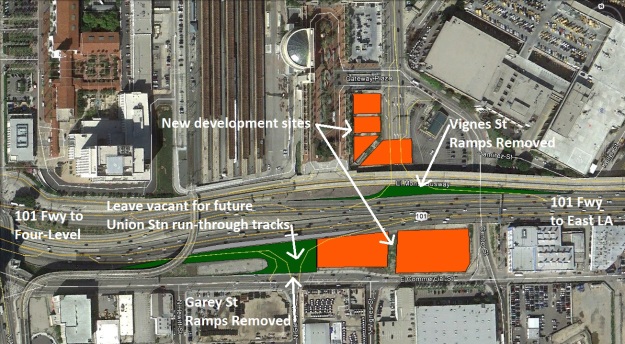
I like to call this style of interchange a “kiss interchange” since the ramp termini look like puckered lips in plan view, making it look like the freeway is kissing the other road. Since they’re cheap to build, these are plunked down all over the place on 50s-era freeways. The ramps at Vignes and Garey are all much too close to the preceding and following interchanges, and they’re redundant anyway, so they should all go. Northbound traffic would get off at the new Chavez ramp I mentioned above or at Alameda; southbound traffic would get off at Los Angeles. Traffic entering northbound should enter further north; traffic entering southbound should enter at Los Angeles or from Mission.

101-Vignes-Garey

Alameda/Los Angeles Interchange

The ramp from the 101 north to Alameda should be retained and become one of the primary exits to the downtown area. It takes up little ROW, provides access to Alameda and Union Station, and provides access to other north-south arterials via Arcadia.

The ramp from the 101 south to Los Angeles should be retained and reconfigured to also provide access to Aliso eastbound. Access to Los Angeles northbound is not critical because there is a left from Aliso to Alameda northbound. This allows this ramp to serve the functions of the eliminated Garey St offramp.

The ramp from Los Angeles to the 101 south should be retained and lefts should be permitted from Los Angeles southbound onto this ramp. This ramp becomes one of the main southbound entrance points and assumes the functions of the eliminated Garey St onramp.

The ramp from Los Angeles and Alameda to the 101 north takes up an entire city block, directly across from Union Station. This ramp should be configured as a slip ramp from the intersection of Aliso and Alameda onto the 101 north.

101-Alameda-LA

Spring/Broadway Interchange

The ramp from the 101 south to Broadway is way too close to the onramp from the Four-Level. It should be eliminated and replaced by an extension of Aliso north to Grand and improvements further north. Due to the crazy grade changes in this area, it’s not possible to have the extension of Aliso intersect Hill – it’s too high up.

The ramps from the 101 north to Spring and from Broadway to the 101 north take up an entire city block, have terrible geometry, and are too close to adjacent interchanges. These ramps? Gone. Arcadia should then be extended north to Grand. Again, the grade differences make it impossible for the extension of Arcadia to intersect Hill.

101-Spring-Broadway

Grand/Hope Interchange

It would be nice to turn the loop ramp from the 101 north to Grand into a slip ramp on the south side of Grand, but the severity of the topography in that area would push the ramp too far south, close to the Alameda onramp. Instead, the ramp should duck under the onramps  and in a slightly larger loop and terminate at Grand where the onramps currently start. The onramps to the 101 north should be moved to the west and square up with the extension of Arcadia. I considered sending the offramp to turn right onto Bunker Hill and come out at the intersection with Chavez, but that would add a ton of traffic turning right from Bunker Hill to Chavez and then Chavez to Grand, so I nixed that. I also thought about sending this ramp to the left under the 101 to come out at the intersection of Hope and Temple, where the ramp from the 101 south currently ends, but I don’t think that grading would work.

The 101 south ramp that currently goes to the intersection of Temple and Hope should be reconfigured to square up with the extension of Aliso, and Hope should be extended to that intersection. The offramp to Temple from the Four-Level ramp that heads to the 101 south should be reconfigured to square up with the intersection of Hope and Temple (taking the place of the current ramp from the 101 south).

101-Grand-FL

Another option would be to get rid of the fork of the onramp from Grand that goes to the Four-Level and just let that traffic use Figueroa to the 110. The offramp to Temple and Hope from the Four-Level ramp could be eliminated too, and replaced by a better configuration of the offramp from the 110 south to Figueroa. However, I decided against this option because the ramp from Figueroa to the 110 north and from the 110 south to Figueroa should probably be eliminated as part of rationalizing the ramps on the 110 (more on that another time).

Four-Level Interchange

I’m a little gunshy about going after the Four-Level. After all, it’s basically where freeway engineering was born – the  first high-speed semi-direct interchange ever. But LA ain’t a museum, just ask the people in Beverly Hills buying $10m teardowns. Nostalgia is for chumps. The Four-Level was fully opened in 1953, before the 10 and the 5 were complete. At that time, it was necessary to provide all the movements. But at this point all four movements to the 101 south and from the 101 north may be redundant.

I started looking at options for eliminating and reconfiguring ramps at the Four-Level, but you know what? Any changes to the Four-Level are only about eliminating short weaving distances and redundant ramps on the 101 and the 110. They’re not about improving the streets downtown for pedestrians or cyclists, and they’re not about reducing ROW footprints and opening up land for redevelopment. Now, maybe it’s worth doing some improvements at the Four-Level, but they’re a separate issue from what I’m trying to get with this series of posts, which is better connections from the Union Station area to downtown. So let’s leave the Four-Level alone for the time being.

Other Options Abound

This is, of course, just one option, and there are plenty of other ways you could configure things. Come up with your own, and let’s get to work on convincing the city and Caltrans to do an analysis.

Now We Have Real Estate to Work With

The land vacated by these ramps should be redeveloped. And instead of doing the normal deal where we have a design competition, give the developer unreasonable subsidies, and end up with vacant lots for years, how ‘bout this: zone the land for any residential or commercial use (and industrial for the piece on Commercial St), no parking minimums, no tax abatements or subsidies, no FAR/height limits, no nothing. We just auction it off to the highest bidder with two conditions: no surface parking, and you gotta build something there within 5 years. We should also break up some of the larger blocks into a few different parcels and auction them off separately. You want to buy the whole block, ok, but you have to win the bid for each piece.  It’ll be a fun experiment.

This project really is an all-around win. It opens up new land for urban development, which unlike any of the proposed parks in the area, actually helps connect Union Station and downtown. It fixes dangerous conditions on the freeway that waste capacity. It makes things better for pedestrians and bikes by getting rid of loop ramps and improving the street grid. And the ROW sale would help fund the project. What’s not to like?

Note: you used to be able to import Google Earth images and topographic data into AutoCAD, which was pretty sweet, because you could draw real engineering stuff and then export it back to Google Earth. As part of Google’s continuing campaign to make its products worse, this feature is no longer available. This leaves several crappy options for trying to share this kind of work:

  • Find the best aerial you can get in AutoCAD (often way out of date) and work with that (but then it’s a static picture other people can’t look at in Google Earth).
  • Draw with polygons in Google Earth and hope that the geometry isn’t insane.
  • Draw it in SketchUp, which is basically like trying to cut down a tree with a jackhammer: it’s not that it’s a bad tool, but it’s clearly not designed for this type of work. I could write an entire post on how bad SketchUp is for civil engineering, if I was looking for exercises in futility.

Therefore, for now, I’ve gone for the fast route with questionable accuracy – drawing Google Earth polygons. I’m going to try to update this using SketchUp to verify the geometry and give others the ability to edit, but I’m not making any promises.

Contact me if you want the Google Earth shape files.

Update

At Kenny Easwaran’s suggestion, here is an image of the whole corridor. Click to enlarge. Again, apologies for the low quality, but Google Earth and MS Paint is the fastest way to get it done.

101-all2Going north on the 101, after First St, your exits would be Chavez, Alameda, Grand and the Four-Level. Going south on the 101, after the Four-Level, your exits would be Grand, Los Angeles, and Mission. Your entrances to the 101 north would be Mission, Alameda, and Grand; to the 101 south, Temple/Hope, Los Angeles, and Mission.

The Problem With Palms Blvd

Just around the corner from my apartment in Palms is the neighborhood’s namesake boulevard. Running west from National at a half-diamond interchange with the 10, Palms is a heavily traveled arterial. For most of the way between National and Sawtelle, it is five lanes – two each way with a two-way center left turn lane – plus parking on each side. Between Mentone and Kelton, it’s the same width but with no center lane. Beyond Sawtelle, in Mar Vista, it fades away, losing a lane here and there until becoming a quiet neighborhood street in Venice.

But in my neighborhood, Palms has been set up to move cars, and it does a damn good job of it. Westside motorists have figured out a sneaky advantage of Palms is that it doesn’t have an interchange with the 405, which means it’s free of the spillover congestion that can plague National and Venice. If you’re coming from or going to the east via the 10, Palms is very convenient. Traffic regularly exceeds the 35 mph speed limit. (I was once a passenger in a shuttle that hit 55 mph on a three-block stretch.)

The result is that Palms is dangerous and it feels dangerous. Trying to cross the street at an unsignalized intersection during peak hours is a harrowing experience in a car, let alone as a pedestrian or cyclist. During the day, I generally don’t cross anywhere other than Overland, Motor, or National. I occasionally see cyclists brave the rush of traffic, but it is not something many people would feel comfortable doing. When I’m riding west, I go out of my way to take Tabor or National – I never ride on Palms. It is also dangerous for drivers, because the narrow lanes make it almost impossible to see oncoming traffic without pulling out into it.

PalmsCrash

The present situation is bad, but it is going to get worse when Expo Line Phase 2 opens. Palms is going to be one of the main pedestrian and bike routes to the station, providing a link to bicycle lanes on Motor and Overland, a function it cannot serve well in its current configuration. Unfortunately, the city’s 2010 Bicycle Plan calls for Palms to be Class III bicycle route, which it describes as appropriate for streets with low traffic volumes or wide outside lanes.

Neither of those conditions describes Palms. Traffic volumes are about 25,000-27,000 ADT, which is almost twice that (14,000-15,000 ADT) of the section of Motor that was recently converted from four lanes to three lanes with bike lanes. Palms is also narrow – five lanes of traffic and two lanes of parking in 64’ of roadway width (if you’re being generous) – so narrow, in fact, that I had a hard time believing Google Earth and went out to measure it for myself, an invigorating exercise even at 11 at night. The parking lanes are about 7’ wide, making each travel lane about 10’.

In short, Palms is classic example of an urban street where there is not enough room to make everybody happy. If we want to improve the facility for one set of uses, we are going to have to take space away from other uses. Parking, through traffic, walking, and bicycling – how do we split up the space? At present, the order of priorities seems to be as they are listed. Despite substandard travel lanes, parking has been maintained on both sides. Sidewalks are not generous, but they exist and are buffered by the parking lanes. Cyclists basically get shafted.

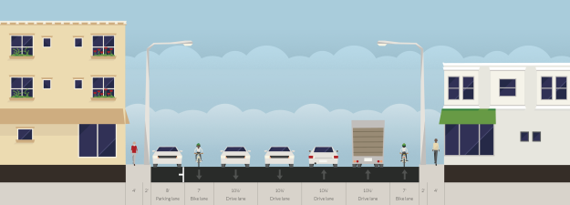
Sharrows just aren’t going to cut it here. The real test of a city’s commitment to safe streets for all is what it does in cases like this, where someone is going to get less than what they want. Thanks to Streetmix, playing around with street cross section is a breeze. Here’s the existing Palms Blvd.

palms-blvd

Now the laziest way to add bike lanes would be to just take the 10’ two-way center left turn lane and chop it up into two 5’ bike lanes. The obvious drawbacks are huge door zone problems (since a 7’ parking lane means the door is already on the stripe), being hard up against trucks in a narrow 10’ travel lane, and the increased danger for drivers turning left. Here’s Option 1:

palms-blvd-option-1

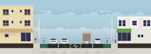
Eliminating a lane of parking would give everyone a little more breathing room. The 7’ bike lanes would probably need striping similar to the buffered bike lane on Montana in Santa Monica, especially where there is no parking, to emphasize that drivers shouldn’t park there. The eliminated lane of parking could alternate sides to always be on the side with more driveways, which would reduce the number of spaces lost. For example, between National and Jasmine, the south side parking would go; from Jasmine to Motor, the north side. As an added complication, there’s the question of how to treat bus stops where the bus would stop in the bike lane. Here’s Option 2:

palms-blvd-option-2

Another option would be retaining the parking and eliminating another travel lane, for a three-lane section. This is probably going to tax the capacity of the remaining travel lane. If we conservatively assume 50% of travel is in the peak 6 hours and a 65-35 directional split, the peak directional volume would be about 1,400 veh/hr – pretty close to the 1,600 veh/hr capacity of a regular traffic lane, and for certain beyond the capacity of the traffic signals. You might note that Palms westbound is currently operating with only one lane underneath the 10 due to Expo Line construction; you might also note that this isn’t working very well, because traffic backs up on National, Manning, and the ramp from the 10 westbound. Here’s Option 3:

palms-blvd-option-3

You could also envision that option with 5’ cycle tracks and 2’ buffers instead of 7’ bike lanes, but I’m not sure Palms (short blocks, many driveways and cross streets, narrow sidewalks which would encourage pedestrians to walk in the track) is the best place for that. One intriguing possibility for a cycle track option would be the ability to use peak-period parking lane conversions to address the traffic capacity issues. During peak periods, parking would be prohibited to provide the same capacity as today. Off-peak, the outside lane would be for parking, which would help discourage speeding when traffic volumes are low. Streetmix doesn’t seem to have the ability to do cycle tracks yet, so you’ll just have to use your noodle. Here’s Option 4:

palms-blvd-option-4

As a final option, you could maintain all the through traffic lanes and convert the parking lanes on both sides to bike lanes. The two-way center left turn lane could be selectively eliminated at bus stops to prevent buses from having to stop in the bike lanes. Here’s Option 5:

palms-blvd-option-5

Note here that in all these options, there is tension between competing uses. The option that saves all the parking and is best for bikes takes away the most traffic capacity. The option that is best for through traffic and bikes takes away parking. And the option that is best for through traffic and parking (i.e. existing configuration) is worst for bikes. The competition for space in cities is natural, and we’re not going to be able to give everybody what they want.

Here’s a summary of the parking lost to Option 2 or Option 5.

PalmsParkingTable

The lost parking could be mitigated by trying to get agreements with local commercial and public properties to allow resident parking at night. Example locations would include the Vons Plaza, Palms Elementary School, the retail parking in the new building at Palms & Motor, Palms Middle School, and the plazas at Palms & Sepulveda. If 89 parking spaces lost is too much for you to accept, you could go with a hybrid of Option 1 between Mentone and Kelton (where there’s no two-way center left turn lane today) and Option 2 elsewhere, which would reduce the parking impact to 46 spaces lost.

My personal order of preference for solutions would be Option 3 or Option 4 (depending on traffic analysis and someone who knows more than me about cycle track design looking at the suitability of Palms for cycle tracks), and then Option 2 or Option 5 (depending on the relative trade-offs of keeping some parking versus keeping the two-way center left turn lane). But even the Option 1/Option 2 hybrid or Option 1 would be an improvement over the way things are today.

Of course, there probably plenty of other alternatives I’m not thinking of, so get over to Streetmix and work up your own option!

Note: I’m showing 6’ as the sidewalk width, even though it’s wider towards the outside in some places, and west of Kelton there are grass strips between the curb and sidewalk. The ROW west of Overland is definitely wider, which would give more flexibility there. I realize that none of these options improve sidewalk width; I’m just looking at what we could do with paint here. Moving the curb requires adjusting drainage inlets and possibly regrading the road, which turns this from essentially a maintenance project into a capital project.

Torre Metafórico

Atlas Obscura has a fascinating look at the Torre de David in Caracas. This is a 45-story skyscraper that was originally intended to be finance industry office space, but construction was abandoned in 1994. Squatters moved in and today it’s the world’s tallest slum. Here’s the documentary:

Rest assured, a copy of that book is now making its way from Switzerland to the Southland. Shipping is free, so it only cost 45 euros (whatever the hell that is). If the current going price for City of Darkness on Amazon is any indication, maybe you should pick up a couple extra copies as an investment.

I bring up City of Darkness because the Kowloon Walled City came to mind as an obvious comparison, as another “vertical slum”. If you read City of Darkness, you’ll notice a striking similarity in the way that residents describe their community and the way that the establishment (governments, architects, urban planners) does.

To hear the authorities tell the tale, these places are overrun with crime and unsafe, the residents helpless victims. In the documentary, the establishment role is played by Guillermo Barrios, a professor of architecture and urbanism, who says that Torre de David is violent, not a good reuse of the structure, an example of “anti-housing” on which the government has turned its back. The Kowloon Walled City, due to arcane details of international relations, was similarly lightly-governed – a tiny island of People’s Republic of China territory surrounded by British Hong Kong.

Ask the people who live there to tell you their stories, and a much more detailed picture emerges. There is crime, like anywhere, but many residents say they feel safe and that nothing has happened to them. The young couple moving into and renovating an apartment are optimistic about getting a home for such a low price, and knowing where they’re going to spend the night. Another resident says the conversion of the tower is just the “nature of life” – people who had nowhere to go when it rains made a place to live. Read City of Darkness and you will hear many similar stories – people who, despite hardship, had escaped worse conditions in the PRC, built homes and businesses, and created a community.

Places that don’t follow the normal rules of development, like Torre de David and the Kowloon Walled City, live in a precarious position. The Kowloon Walled City initially received beneficial intervention from the outside, in the form of sewer lines, safe drinking water spigots, and legitimate power lines that weren’t a serious fire hazard. (Side note: score one for the engineers.) But eventually, its illegal slum apartments and businesses were deemed to be an embarrassment to the British and the Chinese, who both wanted to come out looking good from the 1997 return of Hong Kong to Chinese control, and it was demolished in 1994. This despite the persistence of legal, but just as crappy, cage apartments in the rest of Hong Kong.

The establishment’s position on Torre de David is the same. It is revealing, though perhaps unintentional, that Barrios calls Torre de David a “symbol” of the failure of Venezuela’s cities. Symbolic failures can be solved with symbolic successes. Thus, demolishing a low-rise slum to build Pruitt-Igoe is a success, and demolishing Pruitt-Igoe when it becomes a symbol of urban failure is also a success. Barrios concludes that the people in the tower need to be relocated to “adequate residences, adequately planned around a vision of habitat, of housing with integrated public services”.

Realistically, the physical form of Torre de David has little to do with any social problems, just like physical form had little to do with the problems of pre-WW2 US slums demolished during urban renewal. Social problems are us, and you can’t build new housing to escape yourself. Crime, poverty, lack of economic opportunity, unsafe water, electrical, and sewer service – all of these problems are just as solvable in Torre de David as they would be in some theoretically-planned housing project, if not more, because in Torre de David you can capitalize on existing social networks. But solving symbolic problems is much easier than solving real problems.

Now, this post might seem awfully libertarian to you (I’m surprising myself a little), and you might think I don’t care about people in poor living conditions (not true at all). But that last quote should have sent a chill down your back, because it’s the exact same logic that planners used when they wiped swaths of American cities off the map back in the urban renewal era. My critique isn’t based on Murray Rothbard, it’s straight out of Jane Jacobs.

The stories you hear from residents of Torre de David today were being told by residents of the Kowloon Walled City in 1989, and they could have been told by residents of Boston’s West End in 1955. In every case, residents are saying, look, we want to work with the government to make our community better. And the response of policy thinkers makes it clear they have little interest in that – in actually understanding how the neighborhood works, which Jacobs flagged as one of the biggest problems in urban planning. It makes me really wonder just how much we’ve learned about cities in the last 60 years.

Downtown Wanderings

This is a short setup post with some background ideas and information that will be useful for a few posts that I have on my mind.

Jane Jacobs wrote about the forces that cause downtowns to drift, like self-destruction of diversity, and offered some ideas on how city planners could work to stop those forces. Lately, I’m not entirely sure that it’s a bad thing for downtown to wander as economic agglomerations come and go. When downtown shifts, it leaves behind an interest and coherent, and perhaps most importantly, cheap district that will eventually be discovered and put to use in ways no one thought of before. See, for example, the industrial buildings of Soho that became artist spaces, or the SROs and boarded-up hotels of Downtown LA that are turning into fancy lofts.

The original Downtown LA was, of course, the pueblo. By the late 1800s, it migrated south to the area around First and Broadway, though the vestiges of this downtown are basically gone. In the early 1900s, downtown was centered between Main and Hope, from maybe 3rd to 7th. This area has been booming recently; old-timers will tell you about people living in tents on the sidewalk on Spring St and long vacant buildings, but now Skid Row has moved east and the empty buildings are being renovated. LA’s first skyscraper boom moved things west, to the “new downtown” between 1st and 7th, from the 110 to Grand. Now that area seems a little tired, and all the action has moved south again, from Wilshire to Pico, the 110 to Broadway. But who knows, in 20 years, we could be talking about unforeseen redevelopment and action springing up in what used to be the “new downtown”. Predicting the future is hard!

For the most part, we shouldn’t worry too much about downtown wandering. The goal of public policy is to create a solid framework for the city (transpo, utilities, schools, public safety, recreation, etc.) and let the private sector figure out the rest. Sometimes, though, we need to dig a little deeper and figure out what might be holding back the development of a neighborhood. Right now, we have a lot of transportation money being invested in the area between 2nd and Union Station, to the north of downtown, but downtown keeps shifting south. Why?

Union Station already has the Red/Purple Lines, the Gold Line, Metrolink, and Amtrak. It’s got a lot of Metro bus routes and LAX Flyaway. Before long, Regional Connector will bring the Blue/Expo Lines in to connect, and drop three new stations along 2nd at Hope, Broadway, and Central. Metrolink may build through-running tracks, and hopefully before too much longer CAHSR will come to Union Station. Despite the “7th/Metro Center” moniker (a confusing name that should be replaced with “7th/Flower” anyway), Union Station is pretty clearly the transportation hub. But downtown keeps shifting south. Why?

The appeal of the area between Wilshire and Pico is pretty obvious. It’s got a good mix of old buildings that can be renovated, new construction, and parking lots that are cheap to redevelop. It’s close to many restaurants, bars, and LA Live, and it’s got a Ralph’s on 9th, a Target on Figueroa, and a Walgreens and a Rite-Aid on 7th. It’s pretty close to the Blue/Expo Lines and it’s easier to get to the 10 west and the 110 south. I don’t want to suggest taking anything away from this area; its development should be promoted too.

However, given all the money going into transportation between 2nd and Union Station, we ought to take a hard look at why development there has been somewhat muted. Focus on the framework or “bones” of the city, and I see three main issues:

  • The 101, which creates an unpleasant traffic corridor that separates Union Station from downtown.
  • An excessive amount of park space that increases the distance between different land uses.
  • Zoning and an associated concentration of government buildings filled with people who have pretty much the same schedules and types of trips, which impedes the formation of a customer base large and diverse enough to support a wide range of business establishments.

I’ll explore each of these in a more detailed post.

Traffic Calming Gets Coopted

Call it the Law of NIMBY Assimilation: any urban planning or street design concept will eventually be adopted into the NIMBY Cannon as a justification for opposing development.

The LA Times has an article up today about the turning restrictions at National and Motor in my neighborhood, Palms. The restrictions always seemed strange to me, but now they make perfect sense: wealthy people in Cheviot Hills demanded these traffic calming measures. . .

Wait, what? Traffic calming? Turning restrictions like these can be used as traffic calming measures in places where drivers are trying to get around congested arterials by cutting through small neighborhood streets. Whip out your favorite mapping app and take a look – that doesn’t describe Motor, which was pretty clearly always intended to be an arterial from Culver City to Century City (or Sony to Fox, if you prefer). The developers who laid out Cheviot Hills weren’t idiots – they designed the side streets with an irregular curvilinear grid so that they wouldn’t be logical routes for through traffic. What we have here is not “people are turning onto our side street and doing 45 mph”, but something entirely different: “the city has grown and we don’t care for the results”.

Livable streets advocates might be inclined to support resident efforts to reduce traffic, but this is like the Bus Riders Union backing Beverly Hills lawsuits against the Purple Line: in general, it’s not a good idea to give your support to people who fundamentally disagree with your principles, even if they’ve somehow reached the same conclusion as you.

The mindset that lets people in Cheviot Hills think they shouldn’t have to deal with traffic on Motor is the same mindset that lets them think that Expo Phase 2 should be stopped because of obviously specious safety concerns, hyperventilating about the bike path, and a technicality on traffic analysis. It’s the mindset that says Cheviot Hills and Rancho Park should forever remain SFRs despite enormous investment in infrastructure (the 10, the 405, Expo Line, Purple Line) and enormous growth in employment in the surrounding areas. It’s the mindset that says bike lanes must never reduce the availability of street parking. In short, it’s the same mindset that says that existing neighborhoods must be insulated from any change in the city at large. And it needs to stop.

Orange Line Still Golden

Note: special thanks to Jarrett Walker for pushing for a better analysis and some quick feedback.

So the other day, I was talking with Jarrett Walker on Twitter about the Orange Line, which I’ve previously written about, saying that there’s no need to worry about converting to LRT. True to form, Jarrett said that LRT would offer savings on operations costs, and that to know if it makes sense, you’d have to figure out how long it would take to recoup the capital costs through savings on operations.

Real analysis based on numbers? Oh I’ll play your game, you rogue. Let’s crunch some rough numbers and see how long it would take to recoup the capital costs of converting the Orange Line to LRT through operations savings. (Note: the savings is basically labor for drivers; LRT has more specialized infrastructure, so maintenance should cost more.)

First, let’s set the ground rules for this analysis:

  • Assume that during the peak periods, the Orange Line will run 4 minute headways with two buses operating in tandem; this is effectively a 2 minute headway.
  • Off-peak, the Orange Line will run existing headways, but never less frequent than every 10 minutes. (The service today is much less frequent at night, but to level the playing field, let’s bump it up to 10 minutes.)
  • The capacity of an Orange Line vehicle, per LACMTA policy, is 74 riders.
  • An LRT option will run 3-car trains, with capacity of 399 riders, again per LACMTA policy.
  • Therefore, to provide the same capacity, during peak periods the LRT will operate at 10 minute headways.
  • After 7pm, the LRT will run 2-car trains. (This will tilt things in the LRT’s favor. LACMTA said they were planning to do this on the Expo Line when they went from 20-minute to 10-minute evening and late night headways, but I have yet to actually see any shorter trains.)
  • Off-peak, the LRT will operate at the same headway as the existing Orange Line, since the controlling factor will be the desire to provide frequent service, not capacity.
  • Analysis based on most recent NTD vehicle revenue mile operating costs. I multiplied the reported bus cost by 1.3 to account for the larger buses used on the Orange Line.
  • Assume 290 weekday equivalents per year.
  • Assume that it would cost $1.5b to convert the Orange Line to LRT.
  • Assume a discount rate of 3%.

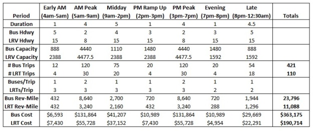
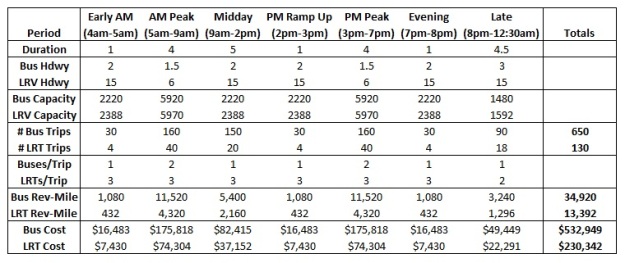
The operating periods, headways, number of trips, revenue vehicle-miles, and costs are summarized in the table below.

OLSG-Table1

Alright, so we aren’t saving any operating costs with those assumptions! Note that we’re providing lots of capacity on the LRT even when we don’t need it. This is one of the strengths of bus – it’s much easier to pare back capacity without having the headway get too long.

Let’s assume ridership goes up and we have to double the amount of bus service we’re providing. Let’s also relax the off-peak headway on the LRT to 15 minutes so that we’re not throwing out so much unused capacity on that option.

OLSG-Table2

Now, the LRT only costs half as much to run as the bus – operational savings of $50m a year, which is some serious money. However, at a capital cost of $1.5b and an interest rate of 3%, it will take over 75 years to pay off the capital costs through operations savings. That’s probably too long a time frame, because we’re going to have to make some major capital investments in the thing during that time – things like replacing signals and traction power substations, which agencies usually put under capital costs, not maintenance. So it’s still a no go.

Here’s another shot at bumping up the frequency of the bus. In this case, we’re basically providing the same capacity in both options – there’s no wasted capacity for the LRT.

OLSG-Table3

Now we’re saving $88m a year, and we can pay off the capital costs in 24 years, which is definitely a winner. This last option assumes some considerable gains in ridership in both peak and off-peak periods – we’re providing more than five times the peak period capacity that we have today!

However, if things reach that point, we’re pushing the limits of a bus system. For the Orange Line, which intersects major arterials at grade, it’s probably a stretch to say that the bus platoon headways could really go below 2 minutes. LADOT isn’t going to want to make the light cycles that short. It’s also a stretch to say we could berth 80 buses per hour at a typical Orange Line station, and passenger circulation is going to be an issue. (Try to remember berthing, passenger circulation, and dwell times the next time you read Randal O’Toole telling you that a bus lane can run 1200 buses an hour.)

In other words, for the Orange Line, it looks like we’ll hit the physical constraints of the system at about the same time it makes sense to upgrade to LRT to save on operating costs. As I said in my original piece, I don’t think we’re at capacity on the Orange Line, so I think the conclusion of that piece holds up pretty well: for the time being, we should spend our capital dollars elsewhere.

Notes

  1. Before any LRT haters jump on this, let’s note that the analysis here is a peculiar case of replacing an existing BRT with LRT, so we have to earn back the entire capital cost of the LRT through operating savings. A much more common analysis would be comparing BRT and LRT at the outset, in which case you have to earn back the difference in capital costs. The Orange Line cost $377m for the initial piece and $215m for the extension, all in 2012 dollars, for a total of $589m, call it $600m. Say that the Orange Line from scratch would cost $1.6b and the difference is $1.0b. The LRT starts to make sense sooner in that case. (Side note: good lord, why did the Orange Line extension cost twice as much per mile as the initial piece?).
  2. The Orange Line is 18 miles long and has 16 stations. The Expo Line is 15 miles long and has 17 stations, and cost about $2.5b. It has occasionally been argued that the cost of upgrading the Orange Line would be less because of the previous investment, but I don’t see how this could be the case. The only thing that could possibly be reused is the at-grade traffic signals, but even those will require modifications. The existing Orange Line stations and guideway will have to be completely demolished and rebuilt. Upgrading the Orange Line to LRT would be cheaper than Expo because the ROW is intact, there is no street running, and the Expo Line has some big time grade separations.
  3. The combination of notes 1 and 2 means that if you’re choosing BRT over LRT, you’d better be pretty sure that you’re not going to hit the capacity of the BRT during the capital depreciation period, say 30 years. The tragedy of upgrading the Orange Line to LRT would not be the time needed to pay back capital costs through operations savings, but the wasted capital expenditure on BRT where we didn’t get our money’s worth. Of course, 30 years is a long time and predicting the future is hard!
  4. This analysis implies that the savings on operating costs could be used to pay down capital costs. Realistically, in most transit agencies the capital and operating sides are separate, so operating savings don’t accrue to the capital budget. That’s really just a matter of accounting though, and not an argument against making smart capital investments that yield long-term savings on operations. In fact, if the operating savings could pay back the capital costs on a reasonable time frame, the agency ought to be able to issue bonds for the capital costs, backed by the operating savings. I’m not aware of an agency that’s tried that though.
  5. Since I obviously did this analysis in Excel, you could easily modify it for a project that interests you. If you want the workbook, get in touch with me and I’ll send it to you.

Principles for Freeway Improvements

Historically, freeway capacity improvements have often been made without putting too much thought into trying to get the most out of existing facilities. Problem: congestion. Solution: MOAR LANES. I think this is for the same reason you see streetcar projects popping up all over the place these days – other people’s money. For a long time, the federal government paid for 90% of freeway construction costs, so states didn’t really care how they spent the money. This has led to maintenance backlogs for states that built more than they could maintain, but that’s a separate problem.

Some readers are no doubt of the opinion that in the long run we should get rid of urban freeways. Let’s leave that debate aside for the moment and note that freeway removals are long-term projects and can be expensive, while the things I’m talking about here are short-term things we can do for cheap.

So, smarter freeway projects. Let’s assume you’ve already taken things like competing against transit and the arguments against new freeway capacity into consideration.  Here’s what you need to pay attention to when you design your project.

Make Things Better for Pedestrians and Bikes

At the end of freeway ramps, cars transition between an exclusive, high-speed facility and local streets, with lower speeds and competing uses. This means ramps are therefore prime locations for terrible incidents with drivers striking pedestrians and bikes. Therefore, it’s important for off-ramps to send a strong message to drivers: you’re not on the freeway anymore, and for on-ramps to send a similar message: you’re not on the freeway yet.

The best way to do this is with design features that force drivers to slow down or stop at the ramp terminus. A hard stop forces you to reset your expectations. To that end, here’s a quick assessment of how different types of interchanges perform:

  • Cloverleaf: probably the worst, since all turns to and from the freeway are free-flowing. Drivers coming off the freeway are likely to keep going too fast, while drivers entering the freeway are likely to accelerate into the ramp, increasing the chance of right-hooking a pedestrian or bicyclist. In addition, the ramp geometry results in long skewed crosswalks or the need to try to force pedestrians out of their way to a shorter crossing. If you try to cross a ramp like this with any regularity, you know how scary they can be.

710willow

Cloverleaf: the 710 at Willow. Note long & skewed crosswalks, large ROW needs, and weaving movements on freeway.

  • Partial cloverleaf: a little better, since it probably introduces a traffic light, but still has some free rights. A four-ramp partial cloverleaf is better than a six-ramp.

91lakewood

Six-ramp partial cloverleaf: the 91 at Lakewood. Less ROW and no weaving on the freeway, but still some free rights. In the SW quadrant, we have a crosswalk that forces pedestrians to take a circuitous path. In the SE quadrant, we have a skewed crosswalk.

405hawthorne

Four-ramp partial cloverleaf: the 405 at Hawthorne. Note that the interchange ROW is tight to the freeway. The ramps intersect Hawthorne at a tight right angle, and this location has no right on red. This forces drivers to stop and reset.

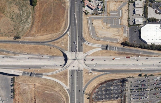
  • Single-point urban interchange (SPUI) and diverging diamond: these interchanges were designed to move as much traffic as quickly as possible. Pedestrian and bike facilities are an afterthought, and to be blunt, they suck. SPUIs and diverging diamonds might be ok in a suburban or rural context, but they don’t belong in cities.

10archibald

SPUI: the 10 at Archibald. The ROW is pretty tight, but the pedestrian crossings are skewed, and drivers are encouraged to speed by free rights.

  • Tight diamond: in this design, the ramps intersect the street in essentially the same configuration as a regular intersection. All traffic, including right turns, must stop before proceeding. This is the safest design for bicyclists and pedestrians, so when urban freeways are reconfigured, this is the design that should be used. Note that a properly designed partial cloverleaf can do this job just as well.

405culver

Tight diamond: the 405 at Culver. Minimal ROW impact, and the intersection of the ramps with Culver is like a normal intersection.

Reduce the ROW Impact of the Freeway

Freeways make gaps in the urban fabric. In newer areas of development that have grown up around freeways, it’s not that big of an issue, but in cities, freeways can be real barriers. Many older freeways were designed with a callous disregard for context, so any reconstruction projects should try to fix these problems.

Happily, there’s a lot of synergy between the goal of making things better for pedestrians and bicyclists and the goal of reducing the ROW impact. The interchange designs that minimize ROW impacts are also the ones that are best for pedestrians and bicyclists. If you’re in a dense urban area, there’s really no reason to ever build a loop ramp. The marginal benefit to traffic is just not worth it. The only exception to this is where the freeway crosses the intersecting road at a skew, like in the four-ramp partial cloverleaf shown above.

Make the Most of Existing Capacity

Adding lanes is the “dumb” solution, because it requires the least amount of thought. You don’t have to do any critical thinking about what’s causing the congestion. But adding lanes is also usually the costliest solution, and the most disruptive to the city, so adding lanes should be the improvement of last resort. That’s not to say it never makes sense. For example, where the 5 drops from five lanes to three lanes in La Mirada, it’s pretty clear that the inconsistent number of lanes is the source of congestion. (Note that theoretically, you could fix this by adding lanes in LA County or removing lanes in Orange County. If we want to do the latter, that’s fine, but we need to explain how we will accommodate the travel demand.)

However, in many cases, congestion is being caused by deficient design on the existing freeway. These issues should always be analyzed and addressed before adding lanes. The most common deficient design feature is inadequate weaving distance. This is a major source of congestion on many older urban freeways, which were built when the understanding of freeways was primitive, and have entrance and exit ramps placed too close together. Some examples of this in Los Angeles are the 10 between Western and the East LA interchange, the 110 between Florence and Adams, the 101 from the East LA interchange to the Hollywood Split, the 405 between Inglewood and the 110, and the horrible weaves on the 110 between the 10 and the Downtown exit, and between 3rd St and the Four-Level.

There are three options for addressing weaving problems caused by close interchange spacing:

  • Eliminate some of the on and off ramps to increase interchange spacing. This is the cheapest option, and it may be possible to recoup some costs by selling the old ROW.
  • Add auxiliary lanes or collector-distributor lanes. This is a moderate cost option aimed at easing, but not eliminating the weave.
  • Braid the ramps. This is an expensive solution requiring bridges, and probably ROW.

There are two key questions in choosing an option: how important is it to provide ramps to all these surface streets, and how much money do you want to spend? If you really need access to all the streets, auxiliary or C-D lanes will help. Braided ramps should be reserved for only the heaviest volume locations.

In general, I think removing ramps is underappreciated as a viable option. You help solve your freeway congestion problem. You save money. And you get to remove through traffic from neighborhood streets that probably shouldn’t have had ramps in the first place. If your interchanges are less than a mile apart, odds are you’re dumping freeway traffic into the wrong places anyway. Removing ramps is a way to improve neighborhoods. What’s not to like? We should be removing more ramps.

There’s also some synergy to be had with the previous two goals. Cloverleaf interchanges inherently have short weaving distances between the loops, so they can also cause congestion. They also take up a lot of ROW. They should be replaced with other interchange designs, preferably tight diamonds or, where the freeway is crossing at a skew, a tight partial cloverleaf. The 710 is littered with 1950s-era cloverleaf setups, so when that project goes forward, they should rebuilt in that manner. As a bonus, turning those interchanges into tight diamonds frees up some ROW that can be sold for commercial development or whatever.

Conclusion

In conclusion, freeway reconstruction projects on the older LA freeways should be looking to do the following:

  • Get rid of ramps where interchanges are too close together.
  • Get rid of loop ramps that waste urban space.
  • Square up ramp junctions and get rid of free right turns to make things safer for pedestrians and bicyclists.

We’ll see these principles in action in a new post soon.