If you follow this blog’s twitter account, you know that engineering & water twitter has been closely watching the situation at the Oroville Dam in northern California. Many people know, conceptually, that much of the water we use in SoCal comes from northern California, but are not familiar with Oroville or the State Water Project. So, here’s a brief introduction to what the State Water Project (SWP) is, what it does, and what’s happening at Oroville now.
The SWP is an important source of water for SoCal, and Lake Oroville is the main reservoir. While popular conception hold that LA’s water comes from the east Sierra and Owens Valley via the LA Aqueduct, over the last 5 years, that facility has only delivered 29% of LA’s water. The SWP is the largest supplier of water to the city of LA, with 48% of LA’s water over the last 5 years coming from the SWP. So what happens at Lake Oroville is of interest to, well, anyone south of Lake Oroville.
The State Water Project: California Dreaming… Big
Everyone knows the split nature of California’s climate: the north is wetter, the south is drier. However, many people and much of the best farmland are in southern California. Over half of the state’s population lives in relatively dry climates south of the Transverse Ranges, which separate the southern quarter of the state from the rest. In addition, California experiences wide swings in annual rainfall, with droughts and floods often following on each other’s heels. In fact, 2014-15 was the driest water year in state history, but 2016-17 may prove to be the wettest.
This situation naturally led to the desire for civil engineering improvements to both prevent devastation from flooding in wet years and store water for human use during drought years. The SWP was conceived to help meet these goals. The map below shows the main components of the SWP.
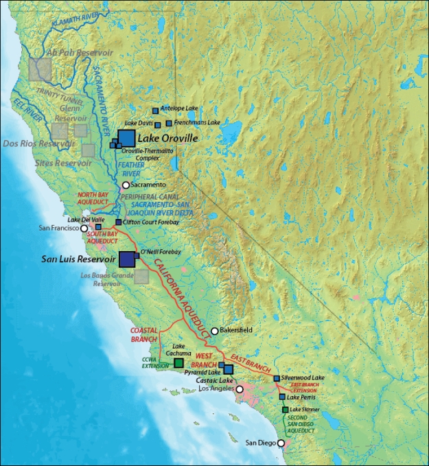
The major components of the SWP are:
- Oroville Dam: this dam is located on the Feather River, which drains a portion of the northern Sierra Nevada, and is the source of water for the SWP. Lake Oroville can store up to 3.5 million acre-feet of water, making it the second largest reservoir in the state after Lake Shasta. One acre-foot of water is enough water to cover an acre of land one foot deep – about 325,000 gallons.
- California Aqueduct: this aqueduct conveys water from the delta to users in central and southern California. Water released from Lake Oroville flows down the Feather River and Sacramento River to the delta. From there it is pumped south out of the Clifton Court Forebay.
- San Luis Reservoir: this is a large off-line reservoir in the southern Central Valley that can store 2 million acre-feet of water. “Off-line reservoir” means that it is not located on a major river – it was created by damming an existing valley and filled with water from the California Aqueduct. The creek that formed the valley, San Luis Creek, would never carry enough water to fill the reservoir on its own.
- Distributary aqueducts: these aqueducts carry water from the main California Aqueduct to water uses. These are:
- North Bay Aqueduct and South Bay Aqueduct, which serve the East Bay area.
- Coastal Branch, which serves San Luis Obispo and Santa Barbara Counties, including a connection to Lake Cachuma, Santa Barbara’s main water supply.
- West Branch, which serves the Los Angeles area and includes Castaic Lake and Pyramid Lake, the lakes you see from the 5 when you drive through the Grapevine.
- East Branch, which serves the Inland Empire and includes Silverwood Lake and Lake Perris.
- Second San Diego Aqueduct, which connects Lake Perris to San Diego County.
Because of the complicated geography and politics of water in California, the SWP includes some water agencies that don’t even have a physical connection to the project. For example, the Desert Water Agency (DWA) and Coachella Water Valley District (CVWD) serve Palm Springs and the Coachella Valley, which have no connection to the SWP. The DWA and CVWD buy SWP water and then swap it with the Metropolitan Water District of Southern California (MWD SoCal) for water from the Colorado River. So DWA and CVWD pay for SWP water, which is delivered to MWD SoCal, and in exchange, MWD SoCal gives DWA and CVWD water from the Colorado River Aqueduct.
Construction on the SWP started in the early 1960s and the major components were done by the late 1970s, though construction on various pieces such as the East Branch Extension continues up to the present day. The SWP is just one legacy of the leadership of Governor Pat Brown, who for his investments in water infrastructure, freeways, and education ought to be known as the father of modern California.
Ok, So What’s Going on at Oroville?
Lake Oroville is a dual-use reservoir – it is used both to store water for human use and to capture water from torrential rainstorms and snowmelt to prevent devastating flooding downstream. Every such reservoir has its storage divided into conservation storage and flood control storage. Under normal conditions during the rainy season, the reservoir is not allowed to fill up beyond the conservation storage level, so that if a big rainstorm or snowmelt event happens, there will be enough capacity to prevent flooding. Reaching the top of conservation storage is like the gas light coming on in your car: it means you need to start looking for a gas station, because you don’t want to run out of gas before you start looking.
Early this week, a large winter storm hit northern California. The storm was warm, meaning that it had high snow levels (the elevation in the mountains where the storm changes from rain to snow), so much of the precipitation went into the rivers right away instead of adding to the snowpack in the mountains. The warm temperatures and rain also caused some of the existing snowpack at low elevations to melt and flow into the rivers.
On Tuesday, Lake Oroville was near the top of conservation storage, and with a large amount of water on its way to enter the lake, state water managers increased water flow through the controlled spillway on the Oroville Dam. A controlled spillway is a structure on a dam that has gates that can be opened and closed by motors, allowing the agency in charge to control how much water leaves the reservoir. The Oroville controlled spillway had a theoretical maximum capacity of 250,000 cubic feet per second.
However, as flows ramped up, a sinkhole appeared in the lower portion of the spillway, and water releases had to be stopped to allow inspection. After assessing options, it was determined that because of the large volume of water entering the lake, it was necessary to continue to allow water to flow through the damaged spillway to keep the lake from rising too quickly. Water flowing through the spillway has caused additional erosion, although yesterday and today the discharge appears less muddy. Hopefully, this is an indication that the channel has cut down to bedrock, and erosion has slowed down.
As water flows downhill, erosion will tend to cut back uphill. This is why Niagara Falls is at the head end of a long gorge; the falls have cut the gorge back upstream from the Niagara Escarpment since the end of the last ice age. It is critical that erosion on the controlled spillway at Oroville not be allowed to proceed uphill and damage the spillway gates, which would negatively impact the ability to control releases down the spillway. That is why the damaged spillway is only being allowed to operate at a reduced capacity.
Because inflow is currently greater than outflow, the lake level is rising. However, this is NOT a threat to the Oroville Dam itself, because there is an emergency spillway that the water will flow over first. The dam crest elevation is at 922’, while the emergency spillway sill is at 901’. The emergency spillway is an uncontrolled weir, so once the lake reaches elevation 901’ water starts to flow down the emergency spillway. This happened at about 8am this morning and as of 3pm February 11, 2017, the lake elevation is at 902.02’, so water continues to flow over the emergency spillway. In a noon press conference, the state announced that it expects this flow to continue for 36-56 hours.
The emergency spillway is an unlined, unimproved channel, which means water that flows over down it is just flowing over dirt, vegetation, and rocks. This means some erosion will occur and enter the Feather River downstream.
What’s Next?
Because it’s only mid-February, winter is only part way over, and more rain and snow storms may be on the way. The state will face challenges with water coming into the lake over the next few months as additional storms hit, and then as spring and summer temperatures melt the snowpack. At the moment, it does not appear there will be enough time to much in the way of repairs before more rain and snow arrive. Resource managers will face difficult decisions between increasing flow on the damaged spillway and allowing additional flows over the emergency spillway.
It’s important to emphasize that as of this writing (3pm February 11, 2017), there is no threat to the Oroville Dam itself, no flooding occurring downstream, and no imminent public danger. Everyone should pay attention to information from the California Department of Water Resources, the Butte County Sheriff, and the California Office of Emergency Services for updates on changing conditions.
After the rainy season and spring snowmelt is over, the state will face a busy summer construction season at Oroville, including repairs to erosion and/or improvements to the emergency spillway, and repairs to the existing damaged controlled spillway or replacement with a new controlled spillway.
Is the SWP the Same Thing as the Central Valley Project?
No, though they are related. The SWP is operated by the state of California, while the Central Valley Project (CVP) is operated by the federal Bureau of Reclamation. The main CVP components are:
- Shasta, Trinity, and Whiskeytown Lakes in northern California, which store water for use in the Central Valley.
- Tehama-Colusa Canal, which distributes water for use in the northern Central Valley.
- Friant Dam and Millerton Lake on the San Joaquin River, and the Friant-Kern Canal, which distribute water from the San Joaquin River for use in the southeastern Central Valley.
- Delta-Mendota Canal, which distributes water from the delta for use the San Joaquin River drainage basin below Friant Dam.
- San Luis Canal, which is shared with the SWP, and distributes water for use in the southwestern Central Valley.
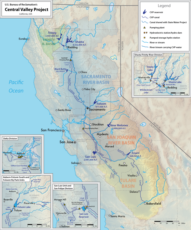
In addition, there are interconnections between the SWP and the CVP such that if the south Sierra has a very wet year, water from the Tulare Basin rivers (Kings, Kaweah, Tulare, and Kern Rivers) can be sent to the SWP.
What Are All Those Grey Squares on the SWP Map?
Curious readers may have noticed several reservoirs and other facilities on the SWP map shown in grey. These are facilities that were proposed as part of the SWP but never constructed.
The undeveloped facilities in northwestern California are of the greatest consequence. The project as originally proposed included dams on the Klamath River and Eel River, which would have created the Ah Pah Reservoir and the Dos Rios Reservoir. At 15 million acre-feet and 7.5 million acre-feet, respectively, each of these reservoirs on their own would have dwarfed Lake Shasta and Lake Oroville. These facilities would have been located in the wettest part of California. An additional reservoir, the Glenn Reservoir, would have been located east of the coastal mountains, with water directed there via tunnel from Dos Rios.

Since the Klamath and Eel Rivers are not currently connected to the SWP, these dams would have greatly increased the water available to the SWP. However, they would have destroyed some of California’s last free-flowing river segments, and would have had enormously negative consequences for fish and other wildlife. The large environmental impacts resulted in these projects being canceled, and they are unlikely to ever be revived.
The other two unbuilt large reservoirs are the Sites Reservoir and Los Banos Grandes Reservoir. The Sites Reservoir would be able to store between 1.2 million and 1.8 million acre-feet, with Los Banos Grandes adding another 1.7 million acre-feet. Together, they would equal another Lake Oroville of off-line reservoir storage, increasing SWP storage by over 50%. Since they would be off-line reservoirs, not located on main rivers, the impact of these facilities might be less.
The last major unbuilt piece of the SWP is the Delta Peripheral Canal, or as we know it today, the Delta Peripheral Tunnel. The purpose of this facility would be to channel water from the Sacramento River (released from Lake Oroville, Lake Shasta, or the Sites Reservoir) around the delta to the pumping facilities that send the water south via the California Aqueduct. This would reduce the environmental impact on the delta and increase the reliability of SWP water deliveries.
With climate change possibly making droughts and floods more likely, and causing precipitation to fall as rain instead of snow, there may be renewed interest in the Sites Reservoir, Delta Peripheral Tunnel, and maybe even Los Banos Grande Reservoir.

Appreciate the time and effort you put into this article. A concise antidote to the inaccuracies spread via social media.
Thanks!!
Awesome unbiased write up, I learned a lot and will be sending a link to everyone I know who is trying to understand what is going on with the dam. Thank you.
Thanks!
This was a great non-engineering synopsis. Thanks for the explanation.
Thanks, glad you found it helpful!
Excellent job.
Here is something you could appreciate, the rules setup regarding the flood plan for the Oroville project.
I wish I had the actual address, but here’s an excerpt, and I’m certain a search will turn up the original.
Yes, they were supposed to build two additional dams, they only completed one, so in truth, the flood plan was incomplete.
Page 7
When the Orville Facilities were
licensed and when the ACE Oroville Dam
Reservoir Regulation Manual was
promulgated, Marysville Dam (federally
authorized in 1966)6
was expected to be
constructed and operational in the near
future. Marysville Dam, located on the
Yuba River system, was envisioned to be
capable of regulating peak flows
(resulting from inflows smaller than the
Figure 4 Civil Works Projects Maps, ACE, Sacramento District, 1978
standard project flood) entering the
Feather River from the Yuba River to 120,000 cfs.
In consideration of the anticipated circumstances of the time, the ACE Oroville Dam
Reservoir Regulation Manual (Reservoir Regulation Manual) prescribes two set of rules
embodied in its flood-control diagrams: an operation with Marysville Dam, and an “interim” or
“present conditions” operation without Marysville Dam. Flood operations with Marysville Dam
(if constructed) feature a 750,000 acre feet flood pool and regulated flood-control diagram
(FCD) releases of up to 150,000 cfs from the gated spillway joined by additional and rising flows
over the ungated “emergency” spillway when reservoir levels rise above elevation 901 feet. The
Here’s page one.
UNITED STATES OF AMERICA
BEFORE THE
FEDERAL ENERGY REGULATORY COMMISSION
In the Matter of ) October 17, 2005
)
State of California )
Department of Water Resources ) Project No. 2100-52
)
For a New Major License )
Oroville Division, State Water Facilities )
“Oroville Facilities” )
MOTION TO INTERVENE
OF
FRIENDS OF THE RIVER
SIERRA CLUB
SOUTH YUBA RIVER CITIZENS LEAGUE
Pursuant to Rule 214 of the Federal Energy Regulatory Commission’s (herinafter “FERC”
or “Commission”) Rules of Practice and Procedure, 18CFR 385.214, Friends of the River, Sierra
Club, and the South Yuba River Citizen’s League move to intervene in the above captioned
proceeding.
DESCRIPTION OF THE INTERVENORS
Friends of the River is a nonprofit 501(c)3 organization headquartered in Sacramento,
California, working to protect, preserve, and restore California rivers and streams for both
environmental and recreational purposes. Friends of the River has approximately 5,000
members in the state of California.
Sierra Club is a nonprofit 501(c)4 organization working to protect the national and world
environment. The Sierra Club has approximately 700,000 members in the United States, and
20,000 members in the Mother Lode Chapter, where the project is located. The Sierra Club
maintains an office in Sacramento, California.
I started my own thread on the subject.
http://conservativehardliner.com/liberals-are-blame-oroville-dam-catastrophe
Outstanding accurate info. Thank you for the maps and background facts.
Pingback: Today’s Headlines – Streetsblog Los Angeles
Pingback: Oroville, Again | Let's Go LA
Just desire to say your article is as astounding.
The clearness to your post is just excellent and that i could think you are knowledgeable in this subject.
Well along with your permission allow me to snatch your feed to keep up to date with imminent
post. Thanks a million and please continue the enjoyable work.